Ecological Indicators ( IF 6.9 ) Pub Date : 2020-09-09 , DOI: 10.1016/j.ecolind.2020.106904 Jarosław Janus , Piotr Bożek , Bartosz Mitka , Jarosław Taszakowski , Arkadiusz Doroż
|
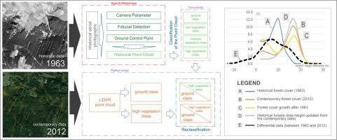
The development of methods for identifying long-term land cover changes is important for many research domains that focus on environmental changes. Analyses of changes in forest vegetation cover are of particular relevance. The interpretation potential of results increases when, in addition to changes in an area occupied by forest cover, we are also able to identify the variability of the area’s height over time. The paper presents a method for precise assessment of changes in forest cover and height over several decades in forests and areas affected by agricultural land abandonment. The data was sourced from two point clouds: one set was collected using airborne laser scanning and represents the current state; the other was obtained from processed monochromatic stereometric aerial images and represents the historical state.
The study involved a dataset made up of nine test fields of 1.3 km2 each. The data processing which was used to obtain a family of universal curves that represents certain aspects of forest cover and height changes during the time interval is described. The proposed approach could standardize the presentation and interpretation of long-term changes caused by agricultural land abandonment, deforestation, regular forestry operations, fires, outbreaks of forest pests, and extreme events like heat waves or droughts. This method can also be used to estimate the approximate point in time when events took place that led to a loss of forest cover. This can improve the accuracy of long-term analyses of the dynamics of the extent of forest cover changes and land abandonment.
中文翻译:
废弃农业用地的长期森林覆盖率和高度变化:基于历史立体图像和机载激光扫描数据的评估
识别长期土地覆盖变化的方法的开发对于许多关注环境变化的研究领域非常重要。对森林植被覆盖度变化的分析特别重要。当除了森林覆盖面积变化之外,我们还能够确定该区域的高度随时间的变化时,结果的解释潜力会增加。本文提出了一种精确评估森林和受农地遗弃影响的地区数十年来森林覆盖率和高度变化的方法。数据来自两个点云:一组是使用机载激光扫描收集的,代表了当前状态;另一个是从经过处理的单色立体航拍图像中获得的,代表了历史状态。
该研究涉及一个由九个测试场组成的数据集,每个测试场的大小为1.3 km 2。描述了用于获得一系列通用曲线的数据处理,这些曲线表示时间间隔内森林覆盖率和高度变化的某些方面。所提议的方法可以使由耕地废弃,森林砍伐,常规的林业经营,火灾,森林病虫害爆发以及热浪或干旱等极端事件引起的长期变化的呈现和解释标准化。该方法还可以用来估计导致森林覆盖率降低的事件发生的大致时间点。这可以提高对森林覆盖率变化和土地废弃程度的动态进行长期分析的准确性。


 京公网安备 11010802027423号