当前位置:
X-MOL 学术
›
Earth Planets Space
›
论文详情
Our official English website, www.x-mol.net, welcomes your feedback! (Note: you will need to create a separate account there.)
Regional probabilistic tsunami hazard assessment associated with active faults along the eastern margin of the Sea of Japan
Earth, Planets and Space ( IF 3.362 ) Pub Date : 2020-09-03 , DOI: 10.1186/s40623-020-01256-5 Iyan E. Mulia , Takeo Ishibe , Kenji Satake , Aditya Riadi Gusman , Satoko Murotani
Earth, Planets and Space ( IF 3.362 ) Pub Date : 2020-09-03 , DOI: 10.1186/s40623-020-01256-5 Iyan E. Mulia , Takeo Ishibe , Kenji Satake , Aditya Riadi Gusman , Satoko Murotani
|
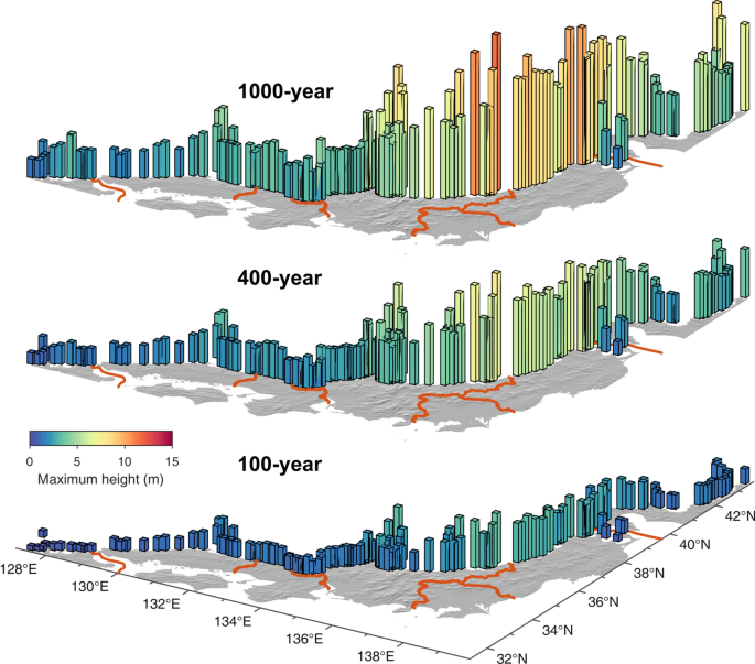
We analyze the regional tsunami hazard along the Sea of Japan coast associated with 60 active faults beneath the eastern margin of the Sea of Japan. We generate stochastic slip distribution using a Monte Carlo approach at each fault, and the total number of required earthquake samples is determined based on convergence analysis of maximum coastal tsunami heights. The earthquake recurrence interval on each fault is estimated from observed seismicity. The variance parameter representing aleatory uncertainty for probabilistic tsunami hazard analysis is determined from comparison with the four historical tsunamis, and a logic-tree is used for the choice of the values. Using nearshore tsunami heights at the 50 m isobath and an amplification factor by the Green’s law, hazard curves are constructed at 154 locations for coastal municipalities along the Sea of Japan coast. The highest maximum coastal tsunamis are expected to be approximately 3.7, 7.7, and 11.5 m for the return periods of 100-, 400-, and 1000-year, respectively. The results indicate that the hazard level generally increases from southwest to northeast, which is consistent with the number and type of the identified fault systems. Furthermore, the deaggregation of hazard suggests that tsunamis in the northeast are predominated by local sources, while the southwest parts are likely affected by several regional sources.
中文翻译:

与日本海东缘活动断层相关的区域概率海啸灾害评估
我们分析了日本海沿岸与日本海东缘下 60 个活动断层相关的区域性海啸灾害。我们在每个断层上使用蒙特卡罗方法生成随机滑动分布,并且所需地震样本的总数是根据最大沿海海啸高度的收敛分析确定的。每个断层的地震复发间隔是根据观测到的地震活动估计的。概率海啸灾害分析中代表偶然不确定性的方差参数是通过与4次历史海啸比较确定的,并采用逻辑树进行取值。使用 50 m 等深线处的近岸海啸高度和格林定律的放大系数,在日本海沿岸的沿海城市的 154 个位置构建了危险曲线。对于 100 年、400 年和 1000 年的重现期,最高的最大沿海海啸预计分别约为 3.7、7.7 和 11.5 m。结果表明,危害程度总体上从西南向东北增加,这与已识别断层系统的数量和类型一致。此外,灾害的分解表明,东北部的海啸主要由本地来源构成,而西南部分可能受到多个区域性来源的影响。结果表明,危害程度总体上从西南向东北增加,这与已识别断层系统的数量和类型一致。此外,灾害的分解表明,东北部的海啸主要由本地来源构成,而西南部分可能受到多个区域性来源的影响。结果表明,危害程度总体上从西南向东北增加,这与识别的断层系统的数量和类型是一致的。此外,灾害的分解表明,东北部的海啸主要由本地来源构成,而西南部分可能受到多个区域性来源的影响。
更新日期:2020-09-03
中文翻译:
与日本海东缘活动断层相关的区域概率海啸灾害评估
我们分析了日本海沿岸与日本海东缘下 60 个活动断层相关的区域性海啸灾害。我们在每个断层上使用蒙特卡罗方法生成随机滑动分布,并且所需地震样本的总数是根据最大沿海海啸高度的收敛分析确定的。每个断层的地震复发间隔是根据观测到的地震活动估计的。概率海啸灾害分析中代表偶然不确定性的方差参数是通过与4次历史海啸比较确定的,并采用逻辑树进行取值。使用 50 m 等深线处的近岸海啸高度和格林定律的放大系数,在日本海沿岸的沿海城市的 154 个位置构建了危险曲线。对于 100 年、400 年和 1000 年的重现期,最高的最大沿海海啸预计分别约为 3.7、7.7 和 11.5 m。结果表明,危害程度总体上从西南向东北增加,这与已识别断层系统的数量和类型一致。此外,灾害的分解表明,东北部的海啸主要由本地来源构成,而西南部分可能受到多个区域性来源的影响。结果表明,危害程度总体上从西南向东北增加,这与已识别断层系统的数量和类型一致。此外,灾害的分解表明,东北部的海啸主要由本地来源构成,而西南部分可能受到多个区域性来源的影响。结果表明,危害程度总体上从西南向东北增加,这与识别的断层系统的数量和类型是一致的。此外,灾害的分解表明,东北部的海啸主要由本地来源构成,而西南部分可能受到多个区域性来源的影响。


 京公网安备 11010802027423号