当前位置:
X-MOL 学术
›
Ecol. Eng.
›
论文详情
Our official English website, www.x-mol.net, welcomes your feedback! (Note: you will need to create a separate account there.)
Determining the width of lake riparian buffer zones for improving water quality base on adjustment of land use structure
Ecological Engineering ( IF 3.8 ) Pub Date : 2020-12-01 , DOI: 10.1016/j.ecoleng.2020.106001 Minghao Wang , Lijie Duan , Jiapan Wang , Jiayu Peng , Binghui Zheng
Ecological Engineering ( IF 3.8 ) Pub Date : 2020-12-01 , DOI: 10.1016/j.ecoleng.2020.106001 Minghao Wang , Lijie Duan , Jiapan Wang , Jiayu Peng , Binghui Zheng
|
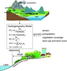
Abstract Lake buffer riparian zones play an essential role in maintaining the sustainability of water quality, reducing sediment accumulation, regulating surface runoff, and protecting biodiversity. However, they are massively degraded over most of the lake basins in the world due to human activities and land-use change in adjacent areas. In this study, the width of the riparian buffer zone was determined around three lakes to achieve a balance between ecological benefits and costs. A modified export coefficient model was used to assess land use and land cover effects on the trophic status of the lake and the environmental benefits of land use structure adjustment. The maximum ratio of benefits obtained to funds invested was utilized for determining the optimal width. The simulation results show that the best results can be obtained after the implementation of the two measures of returning cultivated land to forest and grassland in the buffer zone of 450 m, 100 m and 150 m around Dianchi Lake, Erhai Lake and Fuxian Lake (China), respectively. The ratio of benefits obtained to funds invested of returning cultivated land to grassland was higher than returning cultivated land to forest, about 1.5 times. The results indicated that 24.89 km2, 2.94 km2, 4.30km2 of cultivated land need to be returned to grassland in the riparian buffer zones of Dianchi Lake, Erhai Lake, and Fuxianhu Lake, respectively. It was found that the hydrogeography approach can be successfully implemented to determining the width of lake riparian buffer zones for improving water quality.
中文翻译:

基于土地利用结构调整的湖泊河岸缓冲区宽度确定改善水质
摘要 湖泊缓冲河岸带在维持水质可持续性、减少沉积物堆积、调节地表径流和保护生物多样性方面发挥着重要作用。然而,由于人类活动和邻近地区的土地利用变化,它们在世界上大部分湖盆中都大规模退化。在这项研究中,河岸缓冲区的宽度是在三个湖泊周围确定的,以实现生态效益和成本之间的平衡。修改后的输出系数模型用于评估土地利用和土地覆盖对湖泊营养状况的影响以及土地利用结构调整的环境效益。获得的收益与投资资金的最大比率用于确定最佳宽度。模拟结果表明,在滇池、洱海和抚仙湖周围450 m、100 m和150 m缓冲区实施退耕还林还草两项措施后,效果最佳。 ), 分别。退耕还草取得的收益与投入资金之比高于退耕还林,约为1.5倍。结果表明,滇池、洱海和抚仙湖的滨河缓冲区分别需要退耕还草24.89平方公里、2.94平方公里、4.30平方公里。结果表明,可以成功地实施水文地理学方法来确定湖泊河岸缓冲区的宽度,以改善水质。
更新日期:2020-12-01
中文翻译:
基于土地利用结构调整的湖泊河岸缓冲区宽度确定改善水质
摘要 湖泊缓冲河岸带在维持水质可持续性、减少沉积物堆积、调节地表径流和保护生物多样性方面发挥着重要作用。然而,由于人类活动和邻近地区的土地利用变化,它们在世界上大部分湖盆中都大规模退化。在这项研究中,河岸缓冲区的宽度是在三个湖泊周围确定的,以实现生态效益和成本之间的平衡。修改后的输出系数模型用于评估土地利用和土地覆盖对湖泊营养状况的影响以及土地利用结构调整的环境效益。获得的收益与投资资金的最大比率用于确定最佳宽度。模拟结果表明,在滇池、洱海和抚仙湖周围450 m、100 m和150 m缓冲区实施退耕还林还草两项措施后,效果最佳。 ), 分别。退耕还草取得的收益与投入资金之比高于退耕还林,约为1.5倍。结果表明,滇池、洱海和抚仙湖的滨河缓冲区分别需要退耕还草24.89平方公里、2.94平方公里、4.30平方公里。结果表明,可以成功地实施水文地理学方法来确定湖泊河岸缓冲区的宽度,以改善水质。


 京公网安备 11010802027423号