当前位置:
X-MOL 学术
›
Hydrol. Process.
›
论文详情
Our official English website, www.x-mol.net, welcomes your feedback! (Note: you will need to create a separate account there.)
Field studies on the influence of rainfall intensity, vegetation cover and slope length on soil moisture infiltration on typical watersheds of the Loess Plateau, China
Hydrological Processes ( IF 3.2 ) Pub Date : 2020-08-23 , DOI: 10.1002/hyp.13892 Zimiao He 1 , Peiqing Xiao 2 , Guodong Jia 1 , Ziqiang Liu 3 , Zhenyao Zhang 1 , Xinxiao Yu 1
Hydrological Processes ( IF 3.2 ) Pub Date : 2020-08-23 , DOI: 10.1002/hyp.13892 Zimiao He 1 , Peiqing Xiao 2 , Guodong Jia 1 , Ziqiang Liu 3 , Zhenyao Zhang 1 , Xinxiao Yu 1
Affiliation
|
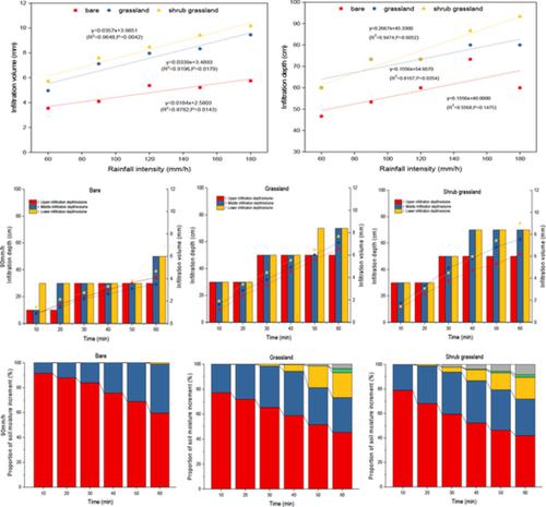
Soil moisture is a key process in the hydrological cycle. During ecological restoration of the Loess Plateau, soil moisture status has undergone important changes, and infiltration of soil moisture during precipitation events is a key link affecting water distribution. Our study aims to quantify the effects of vegetation cover, rainfall intensity and slope length on total infiltration and the spatial variation of water flow. Infiltration data from the upper, middle and lower slopes of a bare slope, a natural grassland and an artificial shrub grassland were obtained using a simulated rainfall experiment. The angle of the study slope was 15° and rainfall intensity was set at 60, 90, 120, 150, and 180 mm/hr. The effect these factors have on soil moisture infiltration was quantified using main effect analysis. Our results indicate that the average infiltration depth (ID) of a bare slope, a grassland slope and an artificial shrub grassland slope was 46.7–73.3, 60–80, and 60–93.3 cm, respectively, and average soil moisture storage increment was 3.5–5.7, 5.0–9.4, and 5.7–10.2 mm under different rainfall intensities, respectively. Heavy rainfall intensity and vegetation cover reduced the difference of soil infiltration in the 0–40 cm soil layer, and rainfall intensity increased surface infiltration differences on the bare slope, the grassland slope and the artificial shrub grassland slope. Infiltration was dominated by rainfall intensity, accounting for 63.03–88.92%. As rainfall continued, the contribution of rainfall intensity to infiltration gradually decreased, and the contribution of vegetation cover and slope length to infiltration increased. The interactive contribution was: rainfall intensity * vegetation cover > vegetation cover * slope length > rainfall * slope length. In the grass and shrub grass slopes, lateral flow was found at a depth of 23–37 cm when the slope length was 5–10 m, this being related to the difference in soil infiltration capacity between different soil layers formed by the spatial cross‐connection of roots.
中文翻译:

黄土高原典型流域降雨强度,植被覆盖度和坡长对土壤水分入渗影响的实地研究
土壤水分是水文循环中的关键过程。在黄土高原生态恢复过程中,土壤水分状况发生了重要变化,降雨过程中土壤水分的渗透是影响水分分布的关键环节。我们的研究旨在量化植被覆盖,降雨强度和边坡长度对总入渗和水流空间变化的影响。利用模拟降雨实验获得了裸露坡度,天然草地和人工灌木草地的上,中,下坡的入渗数据。研究坡度的角度为15°,降雨强度设置为60、90、120、150和180 mm / hr。使用主效应分析定量了这些因素对土壤水分渗透的影响。我们的结果表明,裸坡,草地坡和人工灌木草地坡的平均入渗深度(ID)分别为46.7–73.3、60–80和60–93.3 cm,平均土壤水分存储增量为3.5在不同的降雨强度下分别为–5.7、5.0–9.4和5.7–10.2 mm。大量的降雨强度和植被覆盖减少了0–40 cm土层土壤入渗的差异,降雨强度增加了裸坡,草地坡和人工灌木草地坡的表面入渗差异。降雨强度主要是入渗,占63.03–88.92%。随着降雨的继续,降雨强度对入渗的贡献逐渐减小,植被覆盖度和边坡长度对入渗的贡献增加。相互作用的贡献是:降雨强度*植被覆盖率>植被覆盖率*坡长>降雨*坡长。在草坡和灌木丛坡上,当坡长为5–10 m时,在23–37 cm的深度处发现侧向流,这与空间交叉形成的不同土壤层之间的土壤入渗能力差异有关。根的连接。
更新日期:2020-08-23
中文翻译:
黄土高原典型流域降雨强度,植被覆盖度和坡长对土壤水分入渗影响的实地研究
土壤水分是水文循环中的关键过程。在黄土高原生态恢复过程中,土壤水分状况发生了重要变化,降雨过程中土壤水分的渗透是影响水分分布的关键环节。我们的研究旨在量化植被覆盖,降雨强度和边坡长度对总入渗和水流空间变化的影响。利用模拟降雨实验获得了裸露坡度,天然草地和人工灌木草地的上,中,下坡的入渗数据。研究坡度的角度为15°,降雨强度设置为60、90、120、150和180 mm / hr。使用主效应分析定量了这些因素对土壤水分渗透的影响。我们的结果表明,裸坡,草地坡和人工灌木草地坡的平均入渗深度(ID)分别为46.7–73.3、60–80和60–93.3 cm,平均土壤水分存储增量为3.5在不同的降雨强度下分别为–5.7、5.0–9.4和5.7–10.2 mm。大量的降雨强度和植被覆盖减少了0–40 cm土层土壤入渗的差异,降雨强度增加了裸坡,草地坡和人工灌木草地坡的表面入渗差异。降雨强度主要是入渗,占63.03–88.92%。随着降雨的继续,降雨强度对入渗的贡献逐渐减小,植被覆盖度和边坡长度对入渗的贡献增加。相互作用的贡献是:降雨强度*植被覆盖率>植被覆盖率*坡长>降雨*坡长。在草坡和灌木丛坡上,当坡长为5–10 m时,在23–37 cm的深度处发现侧向流,这与空间交叉形成的不同土壤层之间的土壤入渗能力差异有关。根的连接。


 京公网安备 11010802027423号