当前位置:
X-MOL 学术
›
Earth Surf.Process. Land.
›
论文详情
Our official English website, www.x-mol.net, welcomes your feedback! (Note: you will need to create a separate account there.)
Modelling localized sources of sediment in mountain catchments for provenance studies
Earth Surface Processes and Landforms ( IF 3.3 ) Pub Date : 2020-08-17 , DOI: 10.1002/esp.4979 Giulia Battista 1 , Fritz Schlunegger 2 , Paolo Burlando 1 , Peter Molnar 1
Earth Surface Processes and Landforms ( IF 3.3 ) Pub Date : 2020-08-17 , DOI: 10.1002/esp.4979 Giulia Battista 1 , Fritz Schlunegger 2 , Paolo Burlando 1 , Peter Molnar 1
Affiliation
|
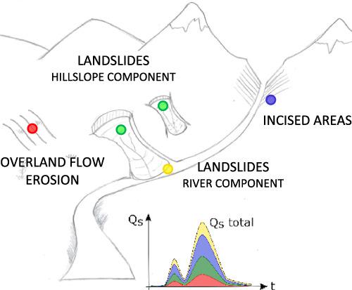
A hydrology–sediment modelling framework based on the model Topkapi‐ETH combined with basin geomorphic mapping is used to investigate the role of localized sediment sources in a mountain river basin (Kleine Emme, Switzerland). The periodic sediment mobilization from incised areas and landslides by hillslope runoff and river discharge is simulated in addition to overland flow erosion to quantify their contributions to suspended sediment fluxes. The framework simulates the suspended sediment load provenance at the outlet and its temporal dynamics, by routing fine sediment along topographically driven pathways from the distinct sediment sources to the outlet. We show that accounting for localized sediment sources substantially improves the modelling of observed sediment concentrations and loads at the outlet compared to overland flow erosion alone. We demonstrate that the modelled river basin can shift between channel‐process and hillslope‐process dominant behaviour depending on the model parameter describing gully competence on landslide surfaces. The simulations in which channel processes dominate were found to be more consistent with observations, and with two independent validations in the Kleine Emme, by topographic analysis of surface roughness and by sediment tracing with 10Be concentrations. This research shows that spatially explicit modelling can be used to infer the dominant sediment production process in a river basin, to inform and optimize sediment sampling strategies for denudation rate estimates, and in general to support sediment provenance studies. © 2020 John Wiley & Sons, Ltd.
中文翻译:

模拟山区流域的局部沉积物来源,以进行物源研究
基于Topkapi-ETH模型并结合盆地地貌测绘的水文-泥沙建模框架被用于研究山区河流盆地(瑞士的Kleine Emme)中局部沉积物来源的作用。除坡面径流侵蚀外,还模拟了坡地径流和河流排泄从切开区域和滑坡中定期动员泥沙,以量化其对悬浮泥沙通量的贡献。该框架通过沿着从不同沉积物源到出口的地形驱动路径路由细沙,模拟了出口处的悬浮泥沙负荷源及其时间动态。我们表明,与单独的陆上径流侵蚀相比,解决局部沉积物来源的问题大大改善了出口处观察到的沉积物浓度和负荷的建模。我们证明,建模的流域可以根据描述滑坡表面沟壑能力的模型参数在河道过程和山坡过程主导行为之间转换。通过对表面粗糙度进行地形分析并通过沉积物追踪,发现通道过程占主导地位的模拟与观测结果更加一致,并且在克莱因·埃姆(Kleine Emme)中进行了两次独立验证。10是浓度。这项研究表明,空间显式建模可用于推断流域的主要沉积物生产过程,为进行剥蚀率估算提供信息并优化沉积物采样策略,并总体上支持沉积物来源研究。分级为4 +©2020 John Wiley&Sons,Ltd.
更新日期:2020-08-17
中文翻译:
模拟山区流域的局部沉积物来源,以进行物源研究
基于Topkapi-ETH模型并结合盆地地貌测绘的水文-泥沙建模框架被用于研究山区河流盆地(瑞士的Kleine Emme)中局部沉积物来源的作用。除坡面径流侵蚀外,还模拟了坡地径流和河流排泄从切开区域和滑坡中定期动员泥沙,以量化其对悬浮泥沙通量的贡献。该框架通过沿着从不同沉积物源到出口的地形驱动路径路由细沙,模拟了出口处的悬浮泥沙负荷源及其时间动态。我们表明,与单独的陆上径流侵蚀相比,解决局部沉积物来源的问题大大改善了出口处观察到的沉积物浓度和负荷的建模。我们证明,建模的流域可以根据描述滑坡表面沟壑能力的模型参数在河道过程和山坡过程主导行为之间转换。通过对表面粗糙度进行地形分析并通过沉积物追踪,发现通道过程占主导地位的模拟与观测结果更加一致,并且在克莱因·埃姆(Kleine Emme)中进行了两次独立验证。10是浓度。这项研究表明,空间显式建模可用于推断流域的主要沉积物生产过程,为进行剥蚀率估算提供信息并优化沉积物采样策略,并总体上支持沉积物来源研究。分级为4 +©2020 John Wiley&Sons,Ltd.


 京公网安备 11010802027423号