Animal Conservation ( IF 3.4 ) Pub Date : 2020-08-13 , DOI: 10.1111/acv.12626 T. Setyawati 1 , S. Nando 1 , W. Marthy 1 , N. Andayani 1 , Sheherazade 1 , M. Linkie 1
|
Protected areas are a cornerstone of biodiversity conservation. They form the basis of national strategies for meeting Convention on Biological Diversity and climate change targets. UNESCO has afforded World Heritage Site (WHS) status to 213 natural sites, primarily protected areas, in recognition of their outstanding universal value. However, 17 of these sites are currently inscribed on the ‘World Heritage in Danger’ list because their integrity and functioning are primarily threatened by anthropogenic threats (UNESCO, 2019). Infrastructure development, notably roads and dams, is the highest ranked threat, accounting for 25% of the inscriptions, including the Tropical Rainforest Heritage of Sumatra (TRHS) in Indonesia, which has been on the Danger List since 2011 (Fig. 1).

source:
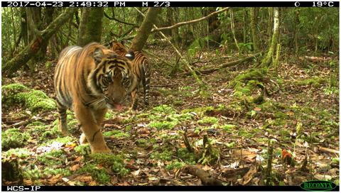
whc.unesco.org/en/danger.] [Colour figure can be viewed at zslpublications.onlinelibrary.wiley.com]The TRHS encompasses a cluster of three national parks (Bukit Barisan Selatan, Kerinci Seblat and Gunung Leuser) covering 2.5 million hectares of rainforest or >4 million hectares with their intact forest landscapes (Fig. 2). These landscapes contain 85% of all Sumatran orangutans Pongo abelii, 65% of Sumatran tigers Panthera tigris sumatrae, 55% of Sumatran elephants Elephas maximus sumatrensis, the only viable population of Sumatran rhinos Dicerorhinus sumatrensis and a wealth of biodiversity (UNESCO, 2011; Fig. 3).


In 2013, the IUCN conducted a monitoring mission to assess the state of the TRHS, including threats and the required corrective measures (IUCN, 2013). From this, criteria for the ‘Desired State of Conservation for the Removal of properties from the List of World Heritage in Danger’ (DSOCR) were developed and ratified by the WHS Committee in 2014 and upheld by an IUCN monitoring mission in 2018 (IUCN, 2018). This describes 12 broad ranging corrective measures, including closing/rehabilitating mines, improving species monitoring and managing the wider landscape. Here, we focus on the measure concerning road development. Based on discussions with colleagues from the ministries of National Development and Planning (BAPPENAS), Public Works and Housing (PUPR) and Environment and Forestry (MoEF), we present three new types of action that are urgently needed to mitigate this threat (Alamgir et al., 2017).
Firstly, we recommend establishing a multi‐agency government body consisting of these three ministries and mandated to address the DSOCR criteria and, more broadly, road construction through forest areas. This would raise awareness of the TRHS issues that require an inter‐agency response, share responsibility among ministries and improve their communication and coordination on this critical issue. Kerinci Seblat National Park provides an example of how this could work. In 2012, local governments proposed nine new roads that, if realized, would fragment the TRHS into ten sections. Despite the roads lacking the required environmental impact assessment and national government approval, partial construction of five began anyway. In 2018, the national park authority assessed all nine road proposals to determine their need and conformity to the prevailing MoEF regulations. The park authority held a workshop in 2019 with local government, Fauna & Flora International (long‐term national park partner), UNESCO, WCS and, for the first time, the three ministries (MoEF, BAPPENAS and PUPR). This produced a set of joint recommendations to: halt road construction because of the predicted detrimental impacts; undertake road impact assessments and formulate appropriate mitigation actions; and, engage the Coordination Ministry of Human Empowerment and Culture, as the responsible party for the WHS.
Secondly, improve the design and implementation of Strategic Environmental Assessments (SEAs) on infrastructure development in forest areas to ensure that they are conducted to a high standard. SEAs are crucial in informing the development of provincial spatial plans and medium‐term (5‐year) economic development plans, which govern the fate of vast areas of forest (GoI, 2009). The SEAs are monitored by the government’s Corruption Eradication Commission, thereby giving them extra weight. To ensure consistency and standards are met, the Government of Indonesia should develop an accredited training syllabus (including training of trainers) that becomes a mandatory part of provincial government annual work plans and budgets. This would empower provincial agencies to run their own trainings and independently conduct high‐impact SEAs. Gunung Leuser National Park provides a recent example of how this could work.

The 2013 and 2018 IUCN missions highlighted two national roads and one provincial (Karo‐Langkat) road that required immediate attention because they bisected Gunung Leuser National Park, including areas frequently used by tiger, elephant and/or orangutan (Fig. 4). The 5‐km Karo‐Langkat road had existed as a gravel path, until it was tarmacked by the army in 1982. The road then became derelict and naturally reforested until it was reopened and resurfaced in 2011 by the North Sumatra provincial government (Sloan et al., 2018). As a step to address this issue, the national park authority is working with PUPR to ensure that the UNESCO‐requested SEA and mitigation plan is prioritized in its 2020–2021 work plan and budget.
Thirdly, we welcome the issuance of the MoEF regulation on road construction in forest areas in 2019 (MoEF, 2019). In relation to this, we encourage related ministries to work together to broaden this regulation to cover all infrastructure, and elevate it to an overarching cross‐sector policy, such as Presidential regulation, that supersedes all existing ministerial regulations and inconsistencies.
The past removal of 15 natural WHS from the danger list took, on average, 9 years (ranging from 2 to 21 years; UNESCO, 2019). This included corrective measures such as road closure in Iguaçu National Park (Brazil, 'in danger' from 1999 to 2001), minimizing environmental damage from a constructed road in Sangay National Park (Ecuador, 1992–2005) and rerouting a planned road in Simien National Park (Ethiopia, 1996–2017) (Figure 1). The three TRHS protected areas span 7 provinces, each with its own subnational government that repeatedly propose new roads, dams and geothermal plants, which are at odds with central government policy and the DSOCR. The challenges are stark, but if they are to be effectively tackled, then an inter‐ministerial body must play a central role in ensuring that infrastructure development adheres to national law, ideally as a new presidential regulation. This approach is broadly applicable across Indonesia’s other forest‐rich provinces, such as West Papua, Papua and North Kalimantan, where >5000 km of roads are planned for construction or being constructed (Alamgir et al., 2019; Sloan et al., 2019).
中文翻译:
计划将苏门答腊联合国教科文组织世界遗产从“危险中”清除
保护区是生物多样性保护的基石。它们是实现《生物多样性公约》和气候变化目标的国家战略的基础。联合国教科文组织承认213个自然遗产,主要是保护区,具有世界遗产(WHS)的地位,以表彰其突出的普遍价值。但是,这些遗址中有17个目前被列入``濒危世界遗产''名录,因为其完整性和功能主要受到人为威胁的威胁(联合国教科文组织,2019年)。基础设施的发展,尤其是道路和水坝,是威胁等级最高的威胁,占铭文的25%,其中包括印度尼西亚的苏门答腊热带雨林遗产(TRHS),该遗产自2011年以来就被列入危险清单(图1)。
来源:
[可以在zslpublications.onlinelibrary.wiley.com上查看颜色数据。TRHS包含三个国家公园(Bukit Barisan Selatan,Kerinci Seblat和Gunung Leuser)的集群,覆盖250万公顷的雨林或400万公顷以上的原始森林景观(图2)。这些景观包含苏门答腊红毛猩猩Pongo abelii的85%,苏门答腊虎的Panthera tigris sumatrae的65%,苏门答腊大象Elephas maximus sumatrensis的55%,苏门答腊犀牛Dicerorhinus sumatrensis唯一可行的种群和丰富的生物多样性(联合国教科文组织,2011 ;图3)
2013年,自然保护联盟(IUCN)进行了一次监测任务,以评估TRHS的状况,包括威胁和所需的纠正措施(IUCN,2013年)。据此,WHS委员会于2014年制定并批准了“希望从濒危世界遗产名录中移走财产的保护状态”(DSOCR)的标准,并于2018年由IUCN监测团(IUCN,2018年)。这描述了12种广泛的纠正措施,包括关闭/修复矿山,改善物种监测和管理更广阔的景观。在这里,我们重点关注与道路发展有关的措施。根据与国家发展计划部(BAPPENAS),公共工程和住房部(PUPR)和环境与林业部(MoEF)的同事的讨论,我们提出了三种迫切需要减轻这种威胁的新行动(Alamgir等等。,2017)。
首先,我们建议建立一个由这三个部委组成的多机构政府机构,其任务是处理DSOCR标准,更广泛地说,是通过林区的道路建设。这将提高对需要机构间应对的TRHS问题的认识,在各部委之间分担责任,并改善各部门在这一关键问题上的沟通与协调。凯林奇·塞布拉特国家公园(Kerinci Seblat National Park)提供了一个示例,说明了该方法的有效性。2012年,地方政府提出了9条新的道路,如能实现,将把TRHS分为10个部分。尽管道路缺乏必要的环境影响评估和国家政府的批准,但还是开始了部分道路的建设(五条)。在2018年,国家公园管理局评估了所有9条道路建议,以确定它们的需求和对MoEF现行法规的符合性。公园管理局于2019年与地方政府,动植物基金会国际组织(长期国家公园合作伙伴),联合国教科文组织,世界自然保护组织以及三个部委(MoEF,BAPPENAS和PUPR)举行了一次研讨会。这产生了一系列联合建议,以:由于预期的有害影响而停止道路建设;进行道路影响评估并制定适当的缓解措施;并与人力资源和文化协调部合作,担任世界人道主义峰会的负责方。三个部委(MoEF,BAPPENAS和PUPR)。这产生了一系列联合建议,以:由于预期的有害影响而停止道路建设;进行道路影响评估并制定适当的缓解措施;并与人力资源和文化协调部合作,担任世界人道主义峰会的负责方。三个部委(MoEF,BAPPENAS和PUPR)。这产生了一系列联合建议,以:由于预期的有害影响而停止道路建设;进行道路影响评估并制定适当的缓解措施;并与人力资源和文化协调部合作,担任世界人道主义峰会的负责方。
第二,改进关于森林地区基础设施发展的战略环境评估(SEA)的设计和实施,以确保进行高标准的评估。SEA对于告知省级空间计划和中期(五年)经济发展计划的发展至关重要,这些计划决定着大片森林的命运(GoI,2009年))。SEA由政府的反腐败委员会进行监控,因此具有更大的分量。为确保达到一致性和标准,印度尼西亚政府应制定经认可的培训课程(包括培训培训师),该课程已成为省政府年度工作计划和预算的强制性组成部分。这将使省级机构有能力开展自己的培训,并独立开展具有影响力的SEA。古纳·勒瑟国家公园(Gunung Leuser National Park)提供了一个最新示例,说明了这是如何工作的。
2013年和2018年的IUCN任务突显了两条国道和一条省道(Karo-Langkat),需要立即予以关注,因为它们将Gunung Leuser国家公园一分为二,包括老虎,大象和/或猩猩经常使用的区域(图4)。长达5公里的Karo-Langkat道路曾作为碎石路存在,直到1982年被军队挡住了柏油路。此路随后被废弃,并自然地重新造林,直到北苏门答腊省政府在2011年重新开放并重铺路面(Sloan等)。等。,2018)。为了解决这个问题,国家公园管理局正在与PUPR合作,以确保在2020-2021年工作计划和预算中优先考虑教科文组织要求的SEA和缓解计划。
第三,我们欢迎2019年发布关于森林地区道路建设的MoEF法规(MoEF,2019)。与此相关,我们鼓励相关部委共同努力,扩大该法规的适用范围,使其涵盖所有基础设施,并将其提升为跨部门的总体政策,例如总统法规,以取代所有现有的部长法规和前后矛盾之处。
过去从危险清单中删除15种自然WHS的平均时间为9年(从2到21年不等;联合国教科文组织,2019年))。其中包括纠正措施,例如伊瓜苏国家公园(巴西,1999年至2001年处于“危险”)的道路封闭,最大限度地减少桑盖国家公园已建道路对环境的破坏(厄瓜多尔,1992–2005年)和重新规划Simien的规划道路国家公园(埃塞俄比亚,1996–2017年)(图1)。TRHS的三个保护区横跨7个省,每个省都有自己的地方政府,这些政府反复提议新的道路,水坝和地热发电厂,这与中央政府的政策和DSOCR背道而驰。挑战是严峻的,但是要想有效应对,部际机构必须在确保基础设施发展遵守国家法律,理想地作为一项新总统法规的过程中发挥核心作用。这种方法广泛适用于印度尼西亚其他森林资源丰富的省份,等,2019 ; Sloan等人,2019)。


 京公网安备 11010802027423号