Geoscience Frontiers ( IF 8.9 ) Pub Date : 2020-08-07 , DOI: 10.1016/j.gsf.2020.06.013 Phuong Thao Thi Ngo , Mahdi Panahi , Khabat Khosravi , Omid Ghorbanzadeh , Narges Kariminejad , Artemi Cerda , Saro Lee
|
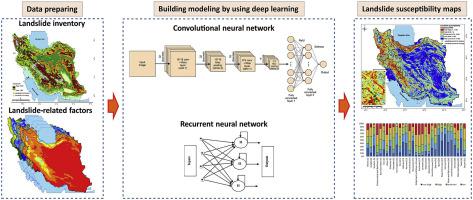
The identification of landslide-prone areas is an essential step in landslide hazard assessment and mitigation of landslide-related losses. In this study, we applied two novel deep learning algorithms, the recurrent neural network (RNN) and convolutional neural network (CNN), for national-scale landslide susceptibility mapping of Iran. We prepared a dataset comprising 4069 historical landslide locations and 11 conditioning factors (altitude, slope degree, profile curvature, distance to river, aspect, plan curvature, distance to road, distance to fault, rainfall, geology and land-sue) to construct a geospatial database and divided the data into the training and the testing dataset. We then developed RNN and CNN algorithms to generate landslide susceptibility maps of Iran using the training dataset. We calculated the receiver operating characteristic (ROC) curve and used the area under the curve (AUC) for the quantitative evaluation of the landslide susceptibility maps using the testing dataset. Better performance in both the training and testing phases was provided by the RNN algorithm (AUC = 0.88) than by the CNN algorithm (AUC = 0.85). Finally, we calculated areas of susceptibility for each province and found that 6% and 14% of the land area of Iran is very highly and highly susceptible to future landslide events, respectively, with the highest susceptibility in Chaharmahal and Bakhtiari Province (33.8%). About 31% of cities of Iran are located in areas with high and very high landslide susceptibility. The results of the present study will be useful for the development of landslide hazard mitigation strategies.
中文翻译:
深度学习算法对伊朗国家滑坡敏感性地图的评估
识别易发生滑坡的区域是滑坡灾害评估和减轻滑坡相关损失的必不可少的步骤。在这项研究中,我们将两种新颖的深度学习算法,即递归神经网络(RNN)和卷积神经网络(CNN),用于伊朗的国家级滑坡敏感性地图。我们准备了一个数据集,包括4069个历史滑坡位置和11个条件因素(海拔,坡度,剖面曲率,到河流的距离,纵横比,平面曲率,到道路的距离,到断层的距离,降雨,地质和土地状况),以构建一个地理空间数据库,并将数据分为训练数据集和测试数据集。然后,我们使用训练数据集开发了RNN和CNN算法,以生成伊朗的滑坡敏感性图。我们计算了接收器的工作特征曲线(ROC),并使用曲线下的面积(AUC)使用测试数据集对滑坡敏感性图进行了定量评估。RNN算法(AUC = 0.88)比CNN算法(AUC = 0.85)在训练和测试阶段都提供了更好的性能。最后,我们计算了每个省的易感面积,发现伊朗土地面积的6%和14%分别高度易受未来滑坡事件的影响,其中在Chaharmahal和Bakhtiari省的易感性最高(33.8%) 。伊朗约31%的城市位于滑坡敏感性很高和非常高的地区。本研究的结果对于开发滑坡灾害减灾策略将是有用的。


 京公网安备 11010802027423号