当前位置:
X-MOL 学术
›
Earth Surf.Process. Land.
›
论文详情
Our official English website, www.x-mol.net, welcomes your feedback! (Note: you will need to create a separate account there.)
Geomorphological evolution of a debris‐covered glacier surface
Earth Surface Processes and Landforms ( IF 3.3 ) Pub Date : 2020-09-21 , DOI: 10.1002/esp.4973 Matthew J. Westoby 1 , David R. Rounce 2, 3 , Thomas E. Shaw 4 , Catriona L. Fyffe 1 , Peter L. Moore 5 , Rebecca L. Stewart 1 , Benjamin W. Brock 1
Earth Surface Processes and Landforms ( IF 3.3 ) Pub Date : 2020-09-21 , DOI: 10.1002/esp.4973 Matthew J. Westoby 1 , David R. Rounce 2, 3 , Thomas E. Shaw 4 , Catriona L. Fyffe 1 , Peter L. Moore 5 , Rebecca L. Stewart 1 , Benjamin W. Brock 1
Affiliation
|
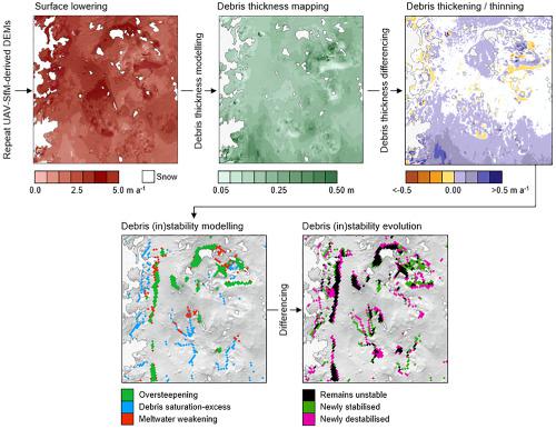
There exists a need to advance our understanding of debris‐covered glacier surfaces over relatively short timescales due to rapid, climatically induced areal expansion of debris cover at the global scale, and the impact debris has on mass balance. We applied unpiloted aerial vehicle structure‐from‐motion (UAV‐SfM) and digital elevation model (DEM) differencing with debris thickness and debris stability modelling to unravel the evolution of a 0.15km region of the debris‐covered Miage Glacier, Italy, between June 2015 and July 2018. DEM differencing revealed widespread surface lowering (mean 4.1 ± 1.0m a; maximum 13.3m a). We combined elevation change data with local meteorological data and a sub‐debris melt model, and used these relationships to produce high resolution, spatially distributed maps of debris thickness. These maps were differenced to explore patterns and mechanisms of debris redistribution. Median debris thicknesses ranged from 0.12 to 0.17m and were spatially variable. We observed localized debris thinning across ice cliff faces, except those which were decaying, where debris thickened. We observed pervasive debris thinning across larger, backwasting slopes, including those bordered by supraglacial streams, as well as ingestion of debris by a newly exposed englacial conduit. Debris stability mapping showed that 18.2–26.4% of the survey area was theoretically subject to debris remobilization. By linking changes in stability to changes in debris thickness, we observed that slopes that remain stable, stabilize, or remain unstable between periods almost exclusively show net debris thickening (mean 0.07m a) whilst those which become newly unstable exhibit both debris thinning and thickening. We observe a systematic downslope increase in the rate at which debris cover thickens which can be described as a function of the topographic position index and slope gradient. Our data provide quantifiable insights into mechanisms of debris remobilization on glacier surfaces over sub‐decadal timescales, and open avenues for future research to explore glacier‐scale spatiotemporal patterns of debris remobilization. © 2020 The Authors. Earth Surface Processes and Landforms published by John Wiley & Sons Ltd
中文翻译:

碎屑覆盖的冰川表面地貌演化
由于全球范围内碎片覆盖的快速、气候引起的面积扩张,以及碎片对质量平衡的影响,有必要在相对较短的时间尺度内提高我们对碎片覆盖的冰川表面的理解。我们应用无人驾驶飞行器运动结构 (UAV-SfM) 和数字高程模型 (DEM) 差分与碎片厚度和碎片稳定性建模,以揭示意大利米格冰川 0.15 公里区域的演变过程。 2015 年 6 月和 2018 年 7 月。 DEM 差异显示广泛的表面降低(平均 4.1 ± 1.0ma;最大 13.3ma)。我们将海拔变化数据与当地气象数据和子碎片熔化模型相结合,并使用这些关系生成高分辨率的碎片厚度空间分布图。这些地图被区分以探索碎片重新分布的模式和机制。平均碎片厚度范围为 0.12 至 0.17m,并且在空间上是可变的。我们观察到冰崖表面的局部碎片变薄,除了那些正在腐烂的碎片变厚的地方。我们观察到在更大的、废弃的斜坡上普遍存在的碎片变薄,包括与冰上溪流接壤的斜坡,以及新暴露的冰河通道吸收碎片。碎片稳定性绘图显示,18.2-26.4% 的调查区域在理论上受到碎片再动员的影响。通过将稳定性的变化与碎片厚度的变化联系起来,我们观察到在不同时期之间保持稳定、稳定或保持不稳定的斜坡几乎完全显示净碎片增厚(平均值为 0. 07m a) 而那些变得新不稳定的碎片表现出碎片变薄和变厚。我们观察到碎屑覆盖层加厚的速度在斜坡下有系统的增加,这可以描述为地形位置指数和坡度梯度的函数。我们的数据提供了对亚年代际时间尺度冰川表面碎片再动员机制的可量化见解,并为未来研究探索冰川尺度碎片再动员的时空模式开辟了道路。© 2020 作者。John Wiley & Sons Ltd 出版的地球表面过程和地貌 我们的数据提供了对次年代时间尺度冰川表面碎片再动员机制的可量化见解,并为未来研究探索冰川尺度碎片再动员的时空模式开辟了道路。© 2020 作者。John Wiley & Sons Ltd 出版的地球表面过程和地貌 我们的数据提供了对次年代时间尺度冰川表面碎片再动员机制的可量化见解,并为未来研究探索冰川尺度碎片再动员的时空模式开辟了道路。© 2020 作者。John Wiley & Sons Ltd 出版的地球表面过程和地貌
更新日期:2020-09-21
中文翻译:
碎屑覆盖的冰川表面地貌演化
由于全球范围内碎片覆盖的快速、气候引起的面积扩张,以及碎片对质量平衡的影响,有必要在相对较短的时间尺度内提高我们对碎片覆盖的冰川表面的理解。我们应用无人驾驶飞行器运动结构 (UAV-SfM) 和数字高程模型 (DEM) 差分与碎片厚度和碎片稳定性建模,以揭示意大利米格冰川 0.15 公里区域的演变过程。 2015 年 6 月和 2018 年 7 月。 DEM 差异显示广泛的表面降低(平均 4.1 ± 1.0ma;最大 13.3ma)。我们将海拔变化数据与当地气象数据和子碎片熔化模型相结合,并使用这些关系生成高分辨率的碎片厚度空间分布图。这些地图被区分以探索碎片重新分布的模式和机制。平均碎片厚度范围为 0.12 至 0.17m,并且在空间上是可变的。我们观察到冰崖表面的局部碎片变薄,除了那些正在腐烂的碎片变厚的地方。我们观察到在更大的、废弃的斜坡上普遍存在的碎片变薄,包括与冰上溪流接壤的斜坡,以及新暴露的冰河通道吸收碎片。碎片稳定性绘图显示,18.2-26.4% 的调查区域在理论上受到碎片再动员的影响。通过将稳定性的变化与碎片厚度的变化联系起来,我们观察到在不同时期之间保持稳定、稳定或保持不稳定的斜坡几乎完全显示净碎片增厚(平均值为 0. 07m a) 而那些变得新不稳定的碎片表现出碎片变薄和变厚。我们观察到碎屑覆盖层加厚的速度在斜坡下有系统的增加,这可以描述为地形位置指数和坡度梯度的函数。我们的数据提供了对亚年代际时间尺度冰川表面碎片再动员机制的可量化见解,并为未来研究探索冰川尺度碎片再动员的时空模式开辟了道路。© 2020 作者。John Wiley & Sons Ltd 出版的地球表面过程和地貌 我们的数据提供了对次年代时间尺度冰川表面碎片再动员机制的可量化见解,并为未来研究探索冰川尺度碎片再动员的时空模式开辟了道路。© 2020 作者。John Wiley & Sons Ltd 出版的地球表面过程和地貌 我们的数据提供了对次年代时间尺度冰川表面碎片再动员机制的可量化见解,并为未来研究探索冰川尺度碎片再动员的时空模式开辟了道路。© 2020 作者。John Wiley & Sons Ltd 出版的地球表面过程和地貌


 京公网安备 11010802027423号