当前位置:
X-MOL 学术
›
Biotropica
›
论文详情
Our official English website, www.x-mol.net, welcomes your feedback! (Note: you will need to create a separate account there.)
Detecting successional changes in tropical forest structure using GatorEye drone‐borne lidar
Biotropica ( IF 2.1 ) Pub Date : 2020-07-30 , DOI: 10.1111/btp.12814 Danilo Roberti Alves Almeida 1, 2 , Angelica Maria Almeyda Zambrano 3 , Eben North Broadbent 2 , Amanda L. Wendt 4, 5 , Paul Foster 6, 7 , Benjamin E. Wilkinson 8 , Carl Salk 9 , Daniel de Almeida Papa 10 , Scott Christopher Stark 11 , Ruben Valbuena 12 , Eric Bastos Gorgens 13 , Carlos Alberto Silva 14, 15 , Pedro Henrique Santin Brancalion 1 , Matthew Fagan 16 , Paula Meli 1, 17 , Robin Chazdon 18, 19
Biotropica ( IF 2.1 ) Pub Date : 2020-07-30 , DOI: 10.1111/btp.12814 Danilo Roberti Alves Almeida 1, 2 , Angelica Maria Almeyda Zambrano 3 , Eben North Broadbent 2 , Amanda L. Wendt 4, 5 , Paul Foster 6, 7 , Benjamin E. Wilkinson 8 , Carl Salk 9 , Daniel de Almeida Papa 10 , Scott Christopher Stark 11 , Ruben Valbuena 12 , Eric Bastos Gorgens 13 , Carlos Alberto Silva 14, 15 , Pedro Henrique Santin Brancalion 1 , Matthew Fagan 16 , Paula Meli 1, 17 , Robin Chazdon 18, 19
Affiliation
|
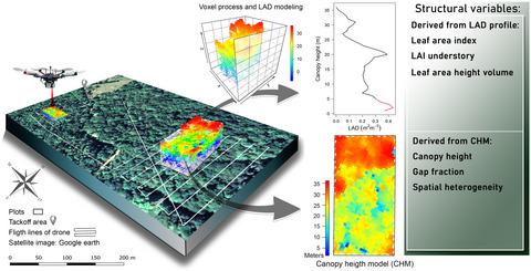
Drone-based remote sensing is a promising new technology that combines the benefits of ground-based and satellite-derived forest monitoring by collecting fine-scale data over relatively large areas in a cost-effective manner. Here, we explore the potential of the GatorEye drone-lidar system to monitor tropical forest succession by canopy structural attributes including canopy height, spatial heterogeneity, gap fraction, leaf area density (LAD) vertical distribution, canopy Shannon index (an index of LAD), leaf area index (LAI), and understory LAI. We focus on these variables? relationship to aboveground biomass (AGB) stocks and species diversity. In the Caribbean lowlands of northeastern Costa Rica, we analyze nine tropical forests stands (seven secondgrowth and two old-growth). Stands were relatively homogenous in terms of canopy height and spatial heterogeneity, but not in their gap fraction. Neither species density nor tree community Shannon diversity index was significantly correlated with the canopy Shannon index. Canopy height, LAI, and AGB did not show a clear pattern as a function of forest age. However, gap fraction and spatial heterogeneity increased with forest age, whereas understory LAI decreased with forest age. Canopy height was strongly correlated with AGB. The heterogeneous mosaic created by successional forest patches across human-managed tropical landscapes can now be better characterized. Drone-lidar systems offer the opportunity to improve assessment of forest recovery and develop general mechanistic carbon sequestration models that can be rapidly deployed to specific sites, an essential step for monitoring progress within the UN Decade on Ecosystem Restoration.
中文翻译:

使用 GatorEye 无人机激光雷达检测热带森林结构的演替变化
基于无人机的遥感是一种很有前途的新技术,它通过以具有成本效益的方式收集相对较大区域的精细数据,结合了地面和卫星衍生的森林监测的优点。在这里,我们探索了 GatorEye 无人机激光雷达系统通过冠层结构属性监测热带森林演替的潜力,包括冠层高度、空间异质性、间隙分数、叶面积密度 (LAD) 垂直分布、冠层香农指数(LAD 的一个指标) 、叶面积指数 (LAI) 和林下 LAI。我们关注这些变量?与地上生物量 (AGB) 储量和物种多样性的关系。在哥斯达黎加东北部的加勒比低地,我们分析了九个热带森林林分(七个次生林和两个老林林)。林分在冠层高度和空间异质性方面相对同质,但在间隙分数方面则不同。物种密度和树木群落香农多样性指数与冠层香农指数均不显着相关。冠层高度、LAI 和 AGB 没有显示出作为森林年龄函数的清晰模式。然而,间隙分数和空间异质性随着森林年龄的增加而增加,而林下LAI随着森林年龄的增加而减少。冠层高度与 AGB 密切相关。现在可以更好地表征由人类管理的热带景观中的连续森林斑块形成的异质马赛克。无人机-激光雷达系统为改进森林恢复评估和开发可快速部署到特定地点的通用机械碳封存模型提供了机会,
更新日期:2020-07-30
中文翻译:
使用 GatorEye 无人机激光雷达检测热带森林结构的演替变化
基于无人机的遥感是一种很有前途的新技术,它通过以具有成本效益的方式收集相对较大区域的精细数据,结合了地面和卫星衍生的森林监测的优点。在这里,我们探索了 GatorEye 无人机激光雷达系统通过冠层结构属性监测热带森林演替的潜力,包括冠层高度、空间异质性、间隙分数、叶面积密度 (LAD) 垂直分布、冠层香农指数(LAD 的一个指标) 、叶面积指数 (LAI) 和林下 LAI。我们关注这些变量?与地上生物量 (AGB) 储量和物种多样性的关系。在哥斯达黎加东北部的加勒比低地,我们分析了九个热带森林林分(七个次生林和两个老林林)。林分在冠层高度和空间异质性方面相对同质,但在间隙分数方面则不同。物种密度和树木群落香农多样性指数与冠层香农指数均不显着相关。冠层高度、LAI 和 AGB 没有显示出作为森林年龄函数的清晰模式。然而,间隙分数和空间异质性随着森林年龄的增加而增加,而林下LAI随着森林年龄的增加而减少。冠层高度与 AGB 密切相关。现在可以更好地表征由人类管理的热带景观中的连续森林斑块形成的异质马赛克。无人机-激光雷达系统为改进森林恢复评估和开发可快速部署到特定地点的通用机械碳封存模型提供了机会,


 京公网安备 11010802027423号