当前位置:
X-MOL 学术
›
Remote Sens. Ecol. Conserv.
›
论文详情
Our official English website, www.x-mol.net, welcomes your feedback! (Note: you will need to create a separate account there.)
Deep learning for coastal resource conservation: automating detection of shellfish reefs
Remote Sensing in Ecology and Conservation ( IF 5.5 ) Pub Date : 2020-02-25 , DOI: 10.1002/rse2.134 Justin T. Ridge 1 , Patrick C. Gray 1 , Anna E. Windle 2 , David W. Johnston 1
Remote Sensing in Ecology and Conservation ( IF 5.5 ) Pub Date : 2020-02-25 , DOI: 10.1002/rse2.134 Justin T. Ridge 1 , Patrick C. Gray 1 , Anna E. Windle 2 , David W. Johnston 1
Affiliation
|
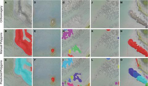
It is increasingly important to understand the extent and health of coastal natural resources in the face of anthropogenic and climate‐driven changes. Coastal ecosystems are difficult to efficiently monitor due to the inability of existing remotely sensed data to capture complex spatial habitat patterns. To help managers and researchers avoid inefficient traditional mapping efforts, we developed a deep learning tool (OysterNet) that uses unoccupied aircraft systems (UAS) imagery to automatically detect and delineate oyster reefs, an ecosystem that has proven problematic to monitor remotely. OysterNet is a convolutional neural network (CNN) that assesses intertidal oyster reef extent, yielding a difference in total area between manual and automated delineations of just 8%, attributable in part to OysterNet's ability to detect oysters overlooked during manual demarcation. Further training of OysterNet could enable assessments of oyster reef heights and densities, and incorporation of more coastal habitat types. Future iterations will be applied to high‐resolution satellite data for effective management at larger scales.
中文翻译:

沿海资源保护的深度学习:自动检测贝类生物礁
面对人为和气候驱动的变化,了解沿海自然资源的范围和健康就变得越来越重要。由于现有遥感数据无法捕获复杂的空间栖息地格局,沿海生态系统难以有效监测。为了帮助管理人员和研究人员避免传统的制图工作效率低下的问题,我们开发了一种深度学习工具(OysterNet),该工具使用无人飞机系统(UAS)图像来自动检测和描绘牡蛎礁,而该生态系统已证明是无法远程监控的。OysterNet是一种卷积神经网络(CNN),用于评估潮间带牡蛎礁的范围,人工和自动划界之间的总面积差异仅为8%,这部分归因于OysterNet' 手动标界中检测到的牡蛎的能力。对OysterNet的进一步培训可以评估牡蛎礁的高度和密度,并纳入更多的沿海生境类型。未来的迭代将应用于高分辨率卫星数据,以便在更大范围内进行有效管理。
更新日期:2020-02-25
中文翻译:
沿海资源保护的深度学习:自动检测贝类生物礁
面对人为和气候驱动的变化,了解沿海自然资源的范围和健康就变得越来越重要。由于现有遥感数据无法捕获复杂的空间栖息地格局,沿海生态系统难以有效监测。为了帮助管理人员和研究人员避免传统的制图工作效率低下的问题,我们开发了一种深度学习工具(OysterNet),该工具使用无人飞机系统(UAS)图像来自动检测和描绘牡蛎礁,而该生态系统已证明是无法远程监控的。OysterNet是一种卷积神经网络(CNN),用于评估潮间带牡蛎礁的范围,人工和自动划界之间的总面积差异仅为8%,这部分归因于OysterNet' 手动标界中检测到的牡蛎的能力。对OysterNet的进一步培训可以评估牡蛎礁的高度和密度,并纳入更多的沿海生境类型。未来的迭代将应用于高分辨率卫星数据,以便在更大范围内进行有效管理。


 京公网安备 11010802027423号