ISPRS Journal of Photogrammetry and Remote Sensing ( IF 12.7 ) Pub Date : 2020-07-12 , DOI: 10.1016/j.isprsjprs.2020.05.015 E. Cledat , L.V. Jospin , D.A. Cucci , J. Skaloud
|
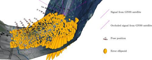
Drone mapping with GNSS-assisted photogrammetry is a highly efficient method for surveying small- or medium-sized areas. However, the mapping quality is not intuitively predictable, particularly in complex environments (with steep and cluttered terrain), in which the quality of the real-time kinematic (RTK) or post-processed kinematic (PPK) positioning varies. We present a method to predict the mapping quality from the information that is available prior to the flight, such as the flight plan, expected flight time, approximate digital terrain model, prevailing surface texture, and embedded sensor characteristics. After detailing the important considerations, we also present the concept of global precision within the context of minimal and efficient ground control point placement in a complex terrain. Finally, we validate the proposed methodology by means of rigorous statistical testing against numerous experiments conducted under different mapping conditions.
中文翻译:
在复杂的自然环境中运行的配备RTK / PPK的微型无人机的制图质量预测
无人机地图和GNSS辅助摄影测量法是一种用于调查中小型区域的高效方法。但是,映射质量不是直观可预测的,尤其是在复杂的环境(地形陡峭且杂乱)中,其中实时运动(RTK)或后处理运动(PPK)定位的质量会发生变化。我们提出了一种根据飞行之前可用的信息来预测地图质量的方法,例如飞行计划,预期飞行时间,近似数字地形模型,主要表面纹理和嵌入式传感器特性。在详细说明了重要的考虑因素之后,我们还介绍了在复杂地形中最小且有效的地面控制点放置范围内的全局精度概念。最后,


 京公网安备 11010802027423号