Pattern Recognition Letters ( IF 5.1 ) Pub Date : 2020-07-07 , DOI: 10.1016/j.patrec.2020.07.003 Daniela Basurto-Lozada , Adeline Hillier , David Medina , Dagoberto Pulido , Sertac Karaman , Joaquin Salas
|
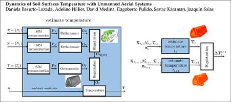
Thermographies are a source of rich information, valuable in precision agriculture tasks such as crop stress assessment, plant disease analysis, and soil moisture evaluation. Traditionally, practitioners obtain soil temperature from the ground or using satellites and other airborne methods, which are costly and offer limited spatial and temporal resolution. In this paper, we introduce a method to measure soil surface temperature dynamics with the use of an unmanned aerial system (UAS). In our approach, we fuse information from thermal and multispectral cameras with ambient variables to generate estimates for soil temperature using computational intelligence models. Using the images, we produce a spatial reconstruction using structure from motion (SfM). After the multimodal registration of the resulting geo-referenced orthomosaics, we characterize the dynamics of the soil surface temperature using the differences between consecutively captured temperature orthomosaics. In our results, we are capable of estimating soil surface temperature from a UAS flying at 30 m AGL with a RMSE of 3.24∘C ± 0.3 and 1.77∘C ± 0.2, at one standard deviation, for two test fields with average ground sampling distances below 6.0 cm/pixel, using a Random Forest regressor.
中文翻译:
无人机系统土壤表面温度的动力学
体温计是丰富信息的来源,在精确农业任务(如作物胁迫评估,植物病害分析和土壤湿度评估)中有价值。传统上,从业人员从地面或使用卫星和其他空中方法获取土壤温度,这既昂贵又提供有限的时空分辨率。在本文中,我们介绍了一种使用无人机系统(UAS)来测量土壤表面温度动态的方法。在我们的方法中,我们将来自热成像仪和多光谱相机的信息与环境变量融合在一起,以使用计算智能模型生成土壤温度的估计值。使用图像,我们使用运动结构(SfM)进行空间重建。在对生成的地理参考矫形器进行多峰注册后,我们利用连续捕获的温度正马赛克之间的差异来表征土壤表面温度的动态变化。在我们的结果中,我们能够从以30 m AGL飞行,RMSE为3.24的UAS估算土壤表面温度。∘ Ç ±0.3和1.77 ∘ Ç ±0.2,在一个标准偏差,对于具有平均地面取样低于6.0厘米/像素的距离,使用随机森林回归两个测试领域。


 京公网安备 11010802027423号