当前位置:
X-MOL 学术
›
Earth Surf.Process. Land.
›
论文详情
Our official English website, www.x-mol.net, welcomes your feedback! (Note: you will need to create a separate account there.)
Assessment of calanchi and rill–interrill erosion susceptibilities using terrain analysis and geostochastics: A case study in the Oltrepo Pavese, Northern Apennines, Italy
Earth Surface Processes and Landforms ( IF 3.3 ) Pub Date : 2020-07-04 , DOI: 10.1002/esp.4949 Alberto Bosino 1 , Paolo Giordani 2 , Geraldine Quénéhervé 1 , Michael Maerker 1
Earth Surface Processes and Landforms ( IF 3.3 ) Pub Date : 2020-07-04 , DOI: 10.1002/esp.4949 Alberto Bosino 1 , Paolo Giordani 2 , Geraldine Quénéhervé 1 , Michael Maerker 1
Affiliation
|
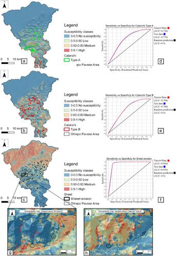
Soil erosion is one of the most important environmental problems distributed worldwide. In the last decades, numerous studies have been published on the assessment of soil erosion and the related processes and forms using empirical, conceptual and physically based models. For the prediction of the spatial distribution, more and more sophisticated stochastic modelling approaches have been proposed – especially on smaller spatial scales such as river basins. In this work, we apply a maximum entropy model (MaxEnt) to evaluate badlands (calanchi) and rill–interrill (sheet erosion) areas in the Oltrepo Pavese (Northern Apennines, Italy). The aim of the work is to assess the important environmental predictors that influence calanchi and rill–interrill erosion at the regional scale. We used 13 topographic parameters derived from a 12 m digital elevation model (TanDEM‐X) and data on the lithology and land use. Additional information about the vegetation is introduced through the normalized difference vegetation index based on remotely sensed data (ASTER images). The results are presented in the form of susceptibility maps showing the spatial distribution of the occurrence probability for calanchi and rill–interrill erosion. For the validation of the MaxEnt model results, a support vector machine approach was applied. The models show reliable results and highlight several locations of the study area that are potentially prone to future soil erosion. Thus, coping and mitigation strategies may be developed to prevent or fight the soil erosion phenomenon under consideration. © 2020 John Wiley & Sons, Ltd.
中文翻译:

使用地形分析和地随机法评估卡兰奇河和小井间钻孔的侵蚀敏感性:以意大利亚平宁山脉北部的奥尔特雷波·帕维斯为例
土壤侵蚀是世界范围内最重要的环境问题之一。在过去的几十年中,已经发表了许多关于使用经验,概念和物理模型对土壤侵蚀以及相关过程和形式进行评估的研究。为了预测空间分布,已经提出了越来越复杂的随机建模方法,尤其是在较小的空间尺度上,例如流域。在这项工作中,我们使用最大熵模型(MaxEnt)来评估Oltrepo Pavese(意大利亚平宁山脉)的荒地(calanchi)和小溪间钻孔(片层侵蚀)区域。这项工作的目的是评估在区域范围内影响卡兰奇和小溪间钻孔侵蚀的重要环境预测因素。我们使用了从12 m数字高程模型(TanDEM‐X)导出的13个地形参数以及岩性和土地利用数据。有关植被的其他信息通过基于遥感数据(ASTER图像)的归一化差异植被指数引入。结果以磁化率图的形式显示,显示了卡兰奇侵蚀和钻头间钻蚀的发生概率的空间分布。为了验证MaxEnt模型结果,应用了支持向量机方法。这些模型显示出可靠的结果,并突出了研究区域的多个位置,这些位置可能会导致未来的水土流失。因此,可以制定应对和缓解策略来预防或抵抗正在考虑的土壤侵蚀现象。分级为4 +©2020 John Wiley&Sons,Ltd.
更新日期:2020-07-04
中文翻译:
使用地形分析和地随机法评估卡兰奇河和小井间钻孔的侵蚀敏感性:以意大利亚平宁山脉北部的奥尔特雷波·帕维斯为例
土壤侵蚀是世界范围内最重要的环境问题之一。在过去的几十年中,已经发表了许多关于使用经验,概念和物理模型对土壤侵蚀以及相关过程和形式进行评估的研究。为了预测空间分布,已经提出了越来越复杂的随机建模方法,尤其是在较小的空间尺度上,例如流域。在这项工作中,我们使用最大熵模型(MaxEnt)来评估Oltrepo Pavese(意大利亚平宁山脉)的荒地(calanchi)和小溪间钻孔(片层侵蚀)区域。这项工作的目的是评估在区域范围内影响卡兰奇和小溪间钻孔侵蚀的重要环境预测因素。我们使用了从12 m数字高程模型(TanDEM‐X)导出的13个地形参数以及岩性和土地利用数据。有关植被的其他信息通过基于遥感数据(ASTER图像)的归一化差异植被指数引入。结果以磁化率图的形式显示,显示了卡兰奇侵蚀和钻头间钻蚀的发生概率的空间分布。为了验证MaxEnt模型结果,应用了支持向量机方法。这些模型显示出可靠的结果,并突出了研究区域的多个位置,这些位置可能会导致未来的水土流失。因此,可以制定应对和缓解策略来预防或抵抗正在考虑的土壤侵蚀现象。分级为4 +©2020 John Wiley&Sons,Ltd.


 京公网安备 11010802027423号