当前位置:
X-MOL 学术
›
Landsc. Urban Plan.
›
论文详情
Our official English website, www.x-mol.net, welcomes your feedback! (Note: you will need to create a separate account there.)
Hot routes in urban forests: The impact of multiple landscape features on recreational use intensity
Landscape and Urban Planning ( IF 9.1 ) Pub Date : 2020-11-01 , DOI: 10.1016/j.landurbplan.2020.103888 Tina Gerstenberg , Christoph F. Baumeister , Ulrich Schraml , Tobias Plieninger
Landscape and Urban Planning ( IF 9.1 ) Pub Date : 2020-11-01 , DOI: 10.1016/j.landurbplan.2020.103888 Tina Gerstenberg , Christoph F. Baumeister , Ulrich Schraml , Tobias Plieninger
|
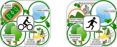
Abstract It is well known that both built and natural landscape features contribute to recreational values of forests. Insights on visual preferences and visitor behaviour are used to meet societal demands for outdoor recreation in forests. However, there is a lack of knowledge on the hierarchy of importance of landscape features that characterise the surroundings of recreational routes for explaining activity-specific use intensity. Furthermore, urban forest managers lack reliable spatial information on which areas are most intensively used for recreation. Therefore, using Public Participation GIS (PPGIS), we invited residents of three densely populated regions in Germany’s Southwest to map their recreational routes in urban forests and report the respective type of activity. Overall, 1136 respondents participated in our study and mapped 2468 routes. We identified two main user groups – cyclists and pedestrians – and created maps that visualise their use intensity. We found recreational use intensity patterns differ for both the three study areas and type of activity. We used linear mixed effects models to identify the contribution of landscape features to overall, cyclists’, and pedestrians’ use intensity. Therefore, we measured area sizes of forest structural attributes, natural area features, and human-made infrastructure for each surrounding area of mapped routes (defined by a 50 m radius). For each mapped route, we calculated the total length of other routes that were within its surrounding area to operationalise recreational use intensity. Results showed that water bodies, broadleaved dominated stands, and unique structural compositions (represented by protected habitats) were among the most important landscape features that explained overall, cyclists’, and pedestrians’ use intensity. We found differences in the importance of landscape features for use intensities between cyclists and pedestrians. Our findings add to previous research since we present a hierarchy of importance of 14 landscape features for explaining residents’ self-mapped recreational behaviour in urban forests. Urban forest managers can use these results to promote outdoor recreation. Furthermore, our hot route maps may help integrating economic, ecological, and social objectives into management plans.
中文翻译:

城市森林中的热门路线:多种景观特征对休闲使用强度的影响
摘要 众所周知,建筑和自然景观特征都有助于森林的娱乐价值。对视觉偏好和游客行为的洞察用于满足社会对森林户外休闲的需求。然而,缺乏对表征休闲路线周围环境的景观特征重要性等级的了解,以解释特定活动的使用强度。此外,城市森林管理者缺乏关于哪些区域最集中用于娱乐的可靠空间信息。因此,我们使用公众参与 GIS (PPGIS),邀请德国西南部三个人口稠密地区的居民绘制他们在城市森林中的休闲路线并报告各自的活动类型。全面的,1136 名受访者参与了我们的研究并绘制了 2468 条路线。我们确定了两个主要用户群——骑自行车的人和行人——并创建了可视化他们使用强度的地图。我们发现三个研究领域和活动类型的娱乐使用强度模式都不同。我们使用线性混合效应模型来确定景观特征对整体、骑自行车者和行人使用强度的贡献。因此,我们测量了地图路线(由 50 m 半径定义)的每个周边区域的森林结构属性、自然区域特征和人造基础设施的面积大小。对于每条映射路线,我们计算了其周边区域内其他路线的总长度,以实现娱乐使用强度。结果表明,水体、阔叶林、独特的结构组成(以受保护的栖息地为代表)是最重要的景观特征之一,可以解释整体、骑自行车者和行人的使用强度。我们发现景观特征对骑自行车者和行人使用强度的重要性存在差异。我们的发现补充了之前的研究,因为我们提出了 14 个景观特征的重要性等级,以解释居民在城市森林中的自我映射娱乐行为。城市森林管理者可以利用这些结果来促进户外休闲活动。此外,我们的热点路线图可能有助于将经济、生态和社会目标纳入管理计划。我们发现景观特征对骑自行车者和行人使用强度的重要性存在差异。我们的发现补充了之前的研究,因为我们提出了 14 个景观特征的重要性等级,以解释居民在城市森林中的自我映射娱乐行为。城市森林管理者可以利用这些结果来促进户外休闲。此外,我们的热点路线图可能有助于将经济、生态和社会目标纳入管理计划。我们发现景观特征对骑自行车者和行人使用强度的重要性存在差异。我们的发现补充了之前的研究,因为我们提出了 14 个景观特征的重要性等级,以解释居民在城市森林中的自我映射娱乐行为。城市森林管理者可以利用这些结果来促进户外休闲。此外,我们的热点路线图可能有助于将经济、生态和社会目标纳入管理计划。
更新日期:2020-11-01
中文翻译:
城市森林中的热门路线:多种景观特征对休闲使用强度的影响
摘要 众所周知,建筑和自然景观特征都有助于森林的娱乐价值。对视觉偏好和游客行为的洞察用于满足社会对森林户外休闲的需求。然而,缺乏对表征休闲路线周围环境的景观特征重要性等级的了解,以解释特定活动的使用强度。此外,城市森林管理者缺乏关于哪些区域最集中用于娱乐的可靠空间信息。因此,我们使用公众参与 GIS (PPGIS),邀请德国西南部三个人口稠密地区的居民绘制他们在城市森林中的休闲路线并报告各自的活动类型。全面的,1136 名受访者参与了我们的研究并绘制了 2468 条路线。我们确定了两个主要用户群——骑自行车的人和行人——并创建了可视化他们使用强度的地图。我们发现三个研究领域和活动类型的娱乐使用强度模式都不同。我们使用线性混合效应模型来确定景观特征对整体、骑自行车者和行人使用强度的贡献。因此,我们测量了地图路线(由 50 m 半径定义)的每个周边区域的森林结构属性、自然区域特征和人造基础设施的面积大小。对于每条映射路线,我们计算了其周边区域内其他路线的总长度,以实现娱乐使用强度。结果表明,水体、阔叶林、独特的结构组成(以受保护的栖息地为代表)是最重要的景观特征之一,可以解释整体、骑自行车者和行人的使用强度。我们发现景观特征对骑自行车者和行人使用强度的重要性存在差异。我们的发现补充了之前的研究,因为我们提出了 14 个景观特征的重要性等级,以解释居民在城市森林中的自我映射娱乐行为。城市森林管理者可以利用这些结果来促进户外休闲活动。此外,我们的热点路线图可能有助于将经济、生态和社会目标纳入管理计划。我们发现景观特征对骑自行车者和行人使用强度的重要性存在差异。我们的发现补充了之前的研究,因为我们提出了 14 个景观特征的重要性等级,以解释居民在城市森林中的自我映射娱乐行为。城市森林管理者可以利用这些结果来促进户外休闲。此外,我们的热点路线图可能有助于将经济、生态和社会目标纳入管理计划。我们发现景观特征对骑自行车者和行人使用强度的重要性存在差异。我们的发现补充了之前的研究,因为我们提出了 14 个景观特征的重要性等级,以解释居民在城市森林中的自我映射娱乐行为。城市森林管理者可以利用这些结果来促进户外休闲。此外,我们的热点路线图可能有助于将经济、生态和社会目标纳入管理计划。


 京公网安备 11010802027423号