当前位置:
X-MOL 学术
›
Earth Surf.Process. Land.
›
论文详情
Our official English website, www.x-mol.net, welcomes your feedback! (Note: you will need to create a separate account there.)
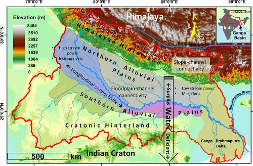
Geomorphic connectivity and its application for understanding landscape complexities: a focus on the hydro‐geomorphic systems of India
Earth Surface Processes and Landforms ( IF 3.3 ) Pub Date : 2020-07-02 , DOI: 10.1002/esp.4945 Manudeo Singh 1 , R. Sinha 1 , S.K. Tandon 2
Earth Surface Processes and Landforms ( IF 3.3 ) Pub Date : 2020-07-02 , DOI: 10.1002/esp.4945 Manudeo Singh 1 , R. Sinha 1 , S.K. Tandon 2
Affiliation
|
Geomorphic processes operate at multiple spatio‐temporal scales and different levels of hierarchy. It is therefore necessary to understand the linkages of landscapes across various scales and levels to gain insights into their interactions and feedbacks. Connectivity is an emergent property of the hydro‐geomorphic systems, and it is gradually evolving into a unifying concept in geomorphology. The connectivity approach has the potential to be applied extensively to diverse hydro‐geomorphic systems of India to understand their complexity as well as for designing effective management practices for river systems and wetlands, optimizing water resources for agriculture, and monitoring and restoration of habitats. Studies on connectivity, particularly in geomorphic context, have been growing steadily in India, albeit at a much slower pace compared to the global trends. This article undertakes a brief overview of the global developments particularly in terms of providing some clarity among the different types of geomorphic connectivity and their inter‐relationships and feedbacks. We then take stock of the connectivity research in India in recent years as applied in different hydrogeomorphic systems across the country. We utilize a number of Indian case studies to illustrate the important developments and applications of connectivity concepts, and also present future perspective of this important field with special relevance to India. © 2020 John Wiley & Sons, Ltd.
中文翻译:

地貌连通性及其在理解景观复杂性中的应用:以印度的水地貌系统为重点
地貌过程在多个时空尺度和不同层次上运行。因此,有必要了解各种规模和级别的景观之间的联系,以深入了解其相互作用和反馈。连接性是水地貌系统的新兴属性,并且正在逐渐演变为地貌学的统一概念。连通性方法有可能被广泛应用于印度的各种水文地貌系统,以了解其复杂性,以及设计有效的河流系统和湿地管理方法,优化农业水资源以及监测和恢复栖息地。在印度,有关连通性的研究(尤其是在地貌方面)一直在稳步增长,与全球趋势相比,速度要慢得多。本文对全球发展进行了简要概述,特别是在使不同类型的地貌连通性及其相互关系和反馈之间具有一定的清晰度方面。然后,我们回顾了近年来印度在印度各地不同水文地貌系统中应用的连通性研究。我们利用许多印度案例研究来说明连通性概念的重要发展和应用,并且还介绍了这一与印度特别相关的重要领域的未来前景。分级为4 +©2020 John Wiley&Sons,Ltd. 本文对全球发展进行了简要概述,特别是在使不同类型的地貌连通性及其相互关系和反馈之间具有一定的清晰度方面。然后,我们回顾了近年来印度在印度各地不同水文地貌系统中应用的连通性研究。我们利用许多印度案例研究来说明连通性概念的重要发展和应用,并且还介绍了这一与印度特别相关的重要领域的未来前景。分级为4 +©2020 John Wiley&Sons,Ltd. 本文对全球发展进行了简要概述,特别是在使不同类型的地貌连通性及其相互关系和反馈之间具有一定的清晰度方面。然后,我们回顾了近年来印度在印度各地不同水文地貌系统中应用的连通性研究。我们利用许多印度案例研究来说明连通性概念的重要发展和应用,并且还介绍了这一与印度特别相关的重要领域的未来前景。分级为4 +©2020 John Wiley&Sons,Ltd. 我们利用许多印度案例研究来说明连通性概念的重要发展和应用,并且还介绍了这一与印度特别相关的重要领域的未来前景。分级为4 +©2020 John Wiley&Sons,Ltd. 我们利用许多印度案例研究来说明连通性概念的重要发展和应用,并且还介绍了这一与印度特别相关的重要领域的未来前景。分级为4 +©2020 John Wiley&Sons,Ltd.
更新日期:2020-07-02
中文翻译:
地貌连通性及其在理解景观复杂性中的应用:以印度的水地貌系统为重点
地貌过程在多个时空尺度和不同层次上运行。因此,有必要了解各种规模和级别的景观之间的联系,以深入了解其相互作用和反馈。连接性是水地貌系统的新兴属性,并且正在逐渐演变为地貌学的统一概念。连通性方法有可能被广泛应用于印度的各种水文地貌系统,以了解其复杂性,以及设计有效的河流系统和湿地管理方法,优化农业水资源以及监测和恢复栖息地。在印度,有关连通性的研究(尤其是在地貌方面)一直在稳步增长,与全球趋势相比,速度要慢得多。本文对全球发展进行了简要概述,特别是在使不同类型的地貌连通性及其相互关系和反馈之间具有一定的清晰度方面。然后,我们回顾了近年来印度在印度各地不同水文地貌系统中应用的连通性研究。我们利用许多印度案例研究来说明连通性概念的重要发展和应用,并且还介绍了这一与印度特别相关的重要领域的未来前景。分级为4 +©2020 John Wiley&Sons,Ltd. 本文对全球发展进行了简要概述,特别是在使不同类型的地貌连通性及其相互关系和反馈之间具有一定的清晰度方面。然后,我们回顾了近年来印度在印度各地不同水文地貌系统中应用的连通性研究。我们利用许多印度案例研究来说明连通性概念的重要发展和应用,并且还介绍了这一与印度特别相关的重要领域的未来前景。分级为4 +©2020 John Wiley&Sons,Ltd. 本文对全球发展进行了简要概述,特别是在使不同类型的地貌连通性及其相互关系和反馈之间具有一定的清晰度方面。然后,我们回顾了近年来印度在印度各地不同水文地貌系统中应用的连通性研究。我们利用许多印度案例研究来说明连通性概念的重要发展和应用,并且还介绍了这一与印度特别相关的重要领域的未来前景。分级为4 +©2020 John Wiley&Sons,Ltd. 我们利用许多印度案例研究来说明连通性概念的重要发展和应用,并且还介绍了这一与印度特别相关的重要领域的未来前景。分级为4 +©2020 John Wiley&Sons,Ltd. 我们利用许多印度案例研究来说明连通性概念的重要发展和应用,并且还介绍了这一与印度特别相关的重要领域的未来前景。分级为4 +©2020 John Wiley&Sons,Ltd.


 京公网安备 11010802027423号