当前位置:
X-MOL 学术
›
Geomorphology
›
论文详情
Our official English website, www.x-mol.net, welcomes your feedback! (Note: you will need to create a separate account there.)
Digital mapping of soil parent material in a heterogeneous tropical area
Geomorphology ( IF 3.9 ) Pub Date : 2020-10-01 , DOI: 10.1016/j.geomorph.2020.107305 Benito R. Bonfatti , José A.M. Demattê , Karina P.P. Marques , Raul R. Poppiel , Rodnei Rizzo , Wanderson de S. Mendes , Nelida E.Q. Silvero , José L. Safanelli
Geomorphology ( IF 3.9 ) Pub Date : 2020-10-01 , DOI: 10.1016/j.geomorph.2020.107305 Benito R. Bonfatti , José A.M. Demattê , Karina P.P. Marques , Raul R. Poppiel , Rodnei Rizzo , Wanderson de S. Mendes , Nelida E.Q. Silvero , José L. Safanelli
|
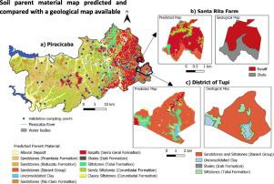
Abstract Parent material is one of the five factors in soil formation. Studies on parent material allow interpreting soil genesis processes and improve our knowledge of specific soil attributes. However, soil parent material maps at detailed cartographic scale (finer than 1:100,000) are rare in tropical areas and it is usually inferred from poorly detailed geological data, which generally group different lithologies into single units. Thus, we propose a methodology to map soil parent material based on remote sensing and machine learning in a geologically very complex area. The study site covers 1378 km2 in Sao Paulo State, Brazil. Prediction models used data from 280 geological observation points, a digital elevation model (spatial resolution of 5 m, upscale to 30 m) and multitemporal Landsat images in a range of 30 years. We evaluated six classification algorithms, namely random forest, decision tree, support vector machine, multinomial logistic regression, K-means (unsupervised classification), and object-based image analysis with maximum likelihood classification. Environmental covariates were grouped to create different scenarios combining terrain derivatives, hydrologic covariates, topsoil spectral reflectance, and spatial coordinates. A bare soil image, elaborated using 30 years of Landsat data, was evaluated as a covariate to predict soil parent material. Predictions were validated using three different strategies: cross-validation, separate validation dataset (20%), and comparison with legacy geological maps (information from two areas with geological maps at fine scale). We also assessed the correspondence between the map of predicted soil parent material and data of soil particle size from 571 soil sampling points. Random forest algorithm presented the best validation performance, whereas the group of terrain derivatives and hydrologic covariates explained most of model variation. The produced parent material map was coherent with the spatial distribution of soil particle size across the study area.
中文翻译:

异质热带地区土壤母质的数字制图
摘要 母质是土壤形成的五个因素之一。对母体材料的研究可以解释土壤发生过程并提高我们对特定土壤属性的了解。然而,详细的制图比例(小于 1:100,000)的土壤母质图在热带地区很少见,通常是从不详细的地质数据中推断出来的,这些数据通常将不同的岩性分组为单个单元。因此,我们提出了一种基于遥感和机器学习在地质非常复杂的地区绘制土壤母质的方法。研究地点位于巴西圣保罗州,占地 1378 平方公里。预测模型使用了来自 280 个地质观测点的数据、数字高程模型(空间分辨率为 5 m,放大到 30 m)和 30 年范围内的多时相 Landsat 图像。我们评估了六种分类算法,即随机森林、决策树、支持向量机、多项逻辑回归、K-means(无监督分类)和基于对象的最大似然分类图像分析。环境协变量被分组以创建不同的场景,结合地形导数、水文协变量、表土光谱反射率和空间坐标。使用 30 年的 Landsat 数据精心制作的裸土图像被评估为预测土壤母质材料的协变量。使用三种不同的策略验证预测:交叉验证、单独的验证数据集 (20%) 和与遗留地质图的比较(来自两个区域的精细地质图的信息)。我们还评估了预测的土壤母质图与来自 571 个土壤采样点的土壤粒度数据之间的对应关系。随机森林算法表现出最好的验证性能,而地形导数和水文协变量组解释了大部分模型变化。生成的母质图与整个研究区域的土壤颗粒大小的空间分布是一致的。
更新日期:2020-10-01
中文翻译:
异质热带地区土壤母质的数字制图
摘要 母质是土壤形成的五个因素之一。对母体材料的研究可以解释土壤发生过程并提高我们对特定土壤属性的了解。然而,详细的制图比例(小于 1:100,000)的土壤母质图在热带地区很少见,通常是从不详细的地质数据中推断出来的,这些数据通常将不同的岩性分组为单个单元。因此,我们提出了一种基于遥感和机器学习在地质非常复杂的地区绘制土壤母质的方法。研究地点位于巴西圣保罗州,占地 1378 平方公里。预测模型使用了来自 280 个地质观测点的数据、数字高程模型(空间分辨率为 5 m,放大到 30 m)和 30 年范围内的多时相 Landsat 图像。我们评估了六种分类算法,即随机森林、决策树、支持向量机、多项逻辑回归、K-means(无监督分类)和基于对象的最大似然分类图像分析。环境协变量被分组以创建不同的场景,结合地形导数、水文协变量、表土光谱反射率和空间坐标。使用 30 年的 Landsat 数据精心制作的裸土图像被评估为预测土壤母质材料的协变量。使用三种不同的策略验证预测:交叉验证、单独的验证数据集 (20%) 和与遗留地质图的比较(来自两个区域的精细地质图的信息)。我们还评估了预测的土壤母质图与来自 571 个土壤采样点的土壤粒度数据之间的对应关系。随机森林算法表现出最好的验证性能,而地形导数和水文协变量组解释了大部分模型变化。生成的母质图与整个研究区域的土壤颗粒大小的空间分布是一致的。


 京公网安备 11010802027423号