当前位置:
X-MOL 学术
›
Q. J. R. Meteorol. Soc.
›
论文详情
Our official English website, www.x-mol.net, welcomes your feedback! (Note: you will need to create a separate account there.)
Using Megha‐Tropiques satellite data to constrain humidity in regional convective simulations: A northern Australian test case
Quarterly Journal of the Royal Meteorological Society ( IF 8.9 ) Pub Date : 2020-05-24 , DOI: 10.1002/qj.3816 Abhnil A. Prasad 1 , Steven C. Sherwood 1 , Hélène Brogniez 2
Quarterly Journal of the Royal Meteorological Society ( IF 8.9 ) Pub Date : 2020-05-24 , DOI: 10.1002/qj.3816 Abhnil A. Prasad 1 , Steven C. Sherwood 1 , Hélène Brogniez 2
Affiliation
|
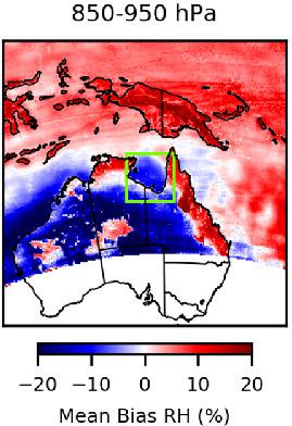
Convective initiation and growth are sensitive to atmospheric conditions, especially humidity, in ways that need to be understood and quantified. It is not clear, however, how well current observations and modelling systems can serve to test this understanding. We simulate multiple cases of convergent cloud lines observed during January 2016 over northeastern Australia using the Weather Research and Forecasting (WRF) model (version 3.7.1), initialized by and nudged to reanalysis data. Overall, WRF appears to skilfully simulate the convergence lines. However, the associated convective clouds as seen by satellite were not properly captured by the model. The model humidity was tested against the current version (V3‐00) of the Megha‐Tropiques satellite, which although up to 30% too moist in the lowest retrieved layer over the dry continental interior compared to radiosondes, is usually accurate to within ±10% near the cloud lines. Unperturbed WRF simulations were found to be 10–20% too dry in this region. Compensating for this humidity bias via the model initialization produced more realistic simulations of clouds and convection, and this had a comparable or larger impact than changing model physics. This result highlights the importance of observations of water vapour that are accurate and have good spatial coverage, especially in the lower troposphere, for properly constraining simulations of convective environments and for model evaluation of moist processes.
中文翻译:

使用Megha-Tropiques卫星数据来限制区域对流模拟中的湿度:北澳大利亚的一个测试案例
对流的启动和生长以需要理解和量化的方式对大气条件特别是湿度敏感。但是,目前的观测和建模系统能否很好地检验这种理解尚不清楚。我们使用天气研究和预报(WRF)模型(版本3.7.1)模拟了澳大利亚东北部2016年1月观测到的汇聚云线的多种情况,并通过初始化和微调来重新分析数据。总体而言,WRF似乎可以巧妙地模拟会聚线。但是,该模型无法正确捕获卫星看到的相关对流云。模型湿度是根据Megha-Tropiques卫星的当前版本(V3-00)进行测试的,尽管与探空仪相比,在干燥的大陆内部最低的回收层中,高达30%的水分过于潮湿,但通常精确到云线附近±10%以内。在该区域,发现不受干扰的WRF模拟过于干燥10–20%。通过模型初始化补偿这种湿度偏差,可以对云和对流进行更真实的模拟,并且与更改模型物理效果相比,具有可比或更大的影响。该结果强调了对水汽的观测准确且具有良好的空间覆盖率(特别是在对流层下部)的重要性,这对于适当限制对流环境的模拟以及对潮湿过程进行模型评估非常重要。在该区域,发现不受干扰的WRF模拟过于干燥10–20%。通过模型初始化补偿这种湿度偏差,可以对云和对流进行更真实的模拟,并且与更改模型物理效果相比,具有可比或更大的影响。该结果强调了对水汽的观测准确且具有良好的空间覆盖率(特别是在对流层下部)的重要性,这对于适当限制对流环境的模拟以及对潮湿过程进行模型评估非常重要。在该区域,发现不受干扰的WRF模拟过于干燥10–20%。通过模型初始化补偿这种湿度偏差,可以对云和对流进行更真实的模拟,并且与更改模型物理效果相比,具有可比或更大的影响。该结果强调了对水汽的观测准确且具有良好的空间覆盖率(特别是在对流层下部)的重要性,这对于适当限制对流环境的模拟以及对潮湿过程进行模型评估非常重要。
更新日期:2020-05-24
中文翻译:
使用Megha-Tropiques卫星数据来限制区域对流模拟中的湿度:北澳大利亚的一个测试案例
对流的启动和生长以需要理解和量化的方式对大气条件特别是湿度敏感。但是,目前的观测和建模系统能否很好地检验这种理解尚不清楚。我们使用天气研究和预报(WRF)模型(版本3.7.1)模拟了澳大利亚东北部2016年1月观测到的汇聚云线的多种情况,并通过初始化和微调来重新分析数据。总体而言,WRF似乎可以巧妙地模拟会聚线。但是,该模型无法正确捕获卫星看到的相关对流云。模型湿度是根据Megha-Tropiques卫星的当前版本(V3-00)进行测试的,尽管与探空仪相比,在干燥的大陆内部最低的回收层中,高达30%的水分过于潮湿,但通常精确到云线附近±10%以内。在该区域,发现不受干扰的WRF模拟过于干燥10–20%。通过模型初始化补偿这种湿度偏差,可以对云和对流进行更真实的模拟,并且与更改模型物理效果相比,具有可比或更大的影响。该结果强调了对水汽的观测准确且具有良好的空间覆盖率(特别是在对流层下部)的重要性,这对于适当限制对流环境的模拟以及对潮湿过程进行模型评估非常重要。在该区域,发现不受干扰的WRF模拟过于干燥10–20%。通过模型初始化补偿这种湿度偏差,可以对云和对流进行更真实的模拟,并且与更改模型物理效果相比,具有可比或更大的影响。该结果强调了对水汽的观测准确且具有良好的空间覆盖率(特别是在对流层下部)的重要性,这对于适当限制对流环境的模拟以及对潮湿过程进行模型评估非常重要。在该区域,发现不受干扰的WRF模拟过于干燥10–20%。通过模型初始化补偿这种湿度偏差,可以对云和对流进行更真实的模拟,并且与更改模型物理效果相比,具有可比或更大的影响。该结果强调了对水汽的观测准确且具有良好的空间覆盖率(特别是在对流层下部)的重要性,这对于适当限制对流环境的模拟以及对潮湿过程进行模型评估非常重要。


 京公网安备 11010802027423号