当前位置:
X-MOL 学术
›
Meteorol. Appl.
›
论文详情
Our official English website, www.x-mol.net, welcomes your feedback! (Note: you will need to create a separate account there.)
Evaluation of convective storms using spaceborne radars over the Indo‐Gangetic Plains and western coast of India
Meteorological Applications ( IF 2.7 ) Pub Date : 2020-05-27 , DOI: 10.1002/met.1917 Rohit Mangla 1 , J. Indu 1, 2 , Venkataraman Lakshmi 3
Meteorological Applications ( IF 2.7 ) Pub Date : 2020-05-27 , DOI: 10.1002/met.1917 Rohit Mangla 1 , J. Indu 1, 2 , Venkataraman Lakshmi 3
Affiliation
|
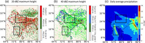
Monsoonal convective systems are examined using four years (2014–2017) of radar reflectivity data from the Precipitation Features (PFs) database of the Global Precipitation Measurement (GPM) Microwave Imager (GMI) and Dual Precipitation Radar (DPR). The study classifies the cumulonimbus tower (PF‐CbT) at 12 km, and intense convective clouds at both 3 km (PF‐ICC3) and 8 km (PF‐ICC8) based on PFs' reflectivity threshold at a reference height over the Indo‐Gangetic Plains (IGP) and Indian Western coastal (WG) region, including the Arabian Sea and the Western Ghats. Results show that the regional variations are more enhanced for the PF‐ICC3 clouds with high occurrence over the IGP region. In the mixed‐phase regime, the median maximum reflectivity is greater for all cloud types over the IGP region. The occurrences of 20 and 40 dBZ echo the top height > 5 km is higher in the IGP region, indicating the deep and intense convection. The aerosol–cloud interaction is examined for warm and mixed‐phase clouds. The vertical structure of aerosols shows the suppression of warm rainfall over the IGP region. However, rainfall intensity increases in mixed‐phase clouds because of the dominancy of ice processes. The significant positive (negative) correlation is observed between the echo top height and aerosol concentrations over the IGP (WG) region. The value of the novel findings clearly states the region‐specific demand for a closer examination of the radar reflectivity–aerosol interaction on regime‐dependent clouds over the IGP region as well as contrasts against other regions for similar and contrasting cloud–aerosol‐radiation interactions.
中文翻译:

利用星载雷达对印度恒河平原和印度西海岸的对流风暴进行评估
利用来自全球降水量测量(GPM)微波成像仪(GMI)和双降水雷达(DPR)的降水特征(PFs)数据库的四年(2014-2017年)雷达反射率数据对季风对流系统进行了检查。根据PFs在印度洋上参考高度的反射率阈值,研究将12 km处的积雨云塔(PF-CbT)和3 km(PF-ICC3)和8 km(PF-ICC8)处的强对流云分类。恒河平原(IGP)和印度西部沿海(WG)地区,包括阿拉伯海和西高止山脉。结果表明,在IGP区域内发生率较高的PF-ICC3云区域差异更大。在混合相状态下,IGP区域内所有云类型的最大反射率中值都更大。发生20和40 dBZ回波在IGP区域的顶部高度> 5 km较高,表明对流较深。检查了气溶胶-云相互作用是否存在暖云和混合云。气溶胶的垂直结构显示出在IGP区域抑制了暖雨。但是,由于制冰过程的优势,混合相云的降雨强度增加。在回波顶部高度和IGP(WG)区域内的气溶胶浓度之间观察到显着的正(负)相关性。这项新发现的价值清楚地表明了特定地区的需求,即需要仔细检查IGP区域上方与政权相关的云层上的雷达反射率-气溶胶相互作用,以及与其他地区进行相似和对比的云-气溶胶-辐射相互作用的对比。
更新日期:2020-05-27
中文翻译:
利用星载雷达对印度恒河平原和印度西海岸的对流风暴进行评估
利用来自全球降水量测量(GPM)微波成像仪(GMI)和双降水雷达(DPR)的降水特征(PFs)数据库的四年(2014-2017年)雷达反射率数据对季风对流系统进行了检查。根据PFs在印度洋上参考高度的反射率阈值,研究将12 km处的积雨云塔(PF-CbT)和3 km(PF-ICC3)和8 km(PF-ICC8)处的强对流云分类。恒河平原(IGP)和印度西部沿海(WG)地区,包括阿拉伯海和西高止山脉。结果表明,在IGP区域内发生率较高的PF-ICC3云区域差异更大。在混合相状态下,IGP区域内所有云类型的最大反射率中值都更大。发生20和40 dBZ回波在IGP区域的顶部高度> 5 km较高,表明对流较深。检查了气溶胶-云相互作用是否存在暖云和混合云。气溶胶的垂直结构显示出在IGP区域抑制了暖雨。但是,由于制冰过程的优势,混合相云的降雨强度增加。在回波顶部高度和IGP(WG)区域内的气溶胶浓度之间观察到显着的正(负)相关性。这项新发现的价值清楚地表明了特定地区的需求,即需要仔细检查IGP区域上方与政权相关的云层上的雷达反射率-气溶胶相互作用,以及与其他地区进行相似和对比的云-气溶胶-辐射相互作用的对比。


 京公网安备 11010802027423号