当前位置:
X-MOL 学术
›
Earth Surf.Process. Land.
›
论文详情
Our official English website, www.x-mol.net, welcomes your feedback! (Note: you will need to create a separate account there.)
Structure‐from‐motion photogrammetry analysis of historical aerial photography: Determining beach volumetric change over decadal scales
Earth Surface Processes and Landforms ( IF 3.3 ) Pub Date : 2020-06-12 , DOI: 10.1002/esp.4911 Rafael C. Carvalho 1 , David M. Kennedy 2, 3 , Yakufu Niyazi 1 , Chloe Leach 2 , Teresa M. Konlechner 2, 3 , Daniel Ierodiaconou 1
Earth Surface Processes and Landforms ( IF 3.3 ) Pub Date : 2020-06-12 , DOI: 10.1002/esp.4911 Rafael C. Carvalho 1 , David M. Kennedy 2, 3 , Yakufu Niyazi 1 , Chloe Leach 2 , Teresa M. Konlechner 2, 3 , Daniel Ierodiaconou 1
Affiliation
|
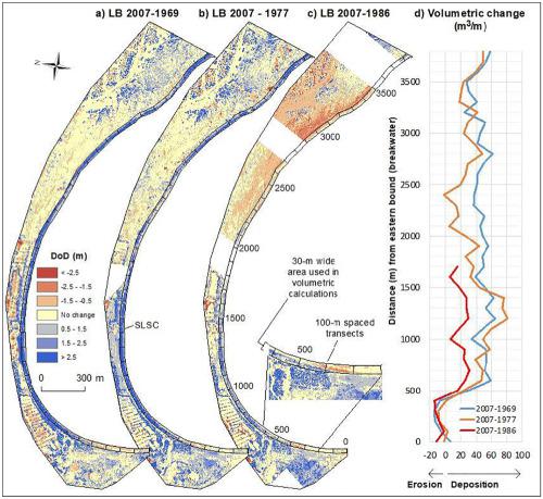
Historical aerial photographs are an invaluable tool in shoreline mapping and change detection in coastal landscapes. We evaluate the extent to which structure‐from‐motion (SfM) photogrammetric methods can be applied to quantify volumetric changes along sandy beaches, using archival imagery. We demonstrate the application of SfM‐derived digital surface models (DSMs) at East Beach and Lady Bay in southwest Victoria, Australia, using photographic datasets taken in 1969, 1977 and 1986, and compare them to LiDAR‐derived DSMs acquired at both sites in 2007. The SfM approaches resulted in two entire and two partial suitable DSMs out of six datasets. Good‐quality DSMs were spatially continuous with a good spread of ground control points (GCPs) near the beach at Lady Bay, whereas unsuitable DSMs were mostly restricted by poor distribution and number of GCPs in spatially segmented areas of East Beach, due to limited overlapping of images, possible poor quality of GCPs and also the propagation of errors in the derived point clouds. A volume of approximately 223 000 ± 72 000 m3 was deposited at Lady Bay between 1969 and 2007, despite minimal erosion observed near the breakwater. The partially suitable dataset of East Beach indicated that beach erosion of at least 39 m3 m−1 occurred immediately to the east of the seawall after 1977. We also discuss the drawbacks and strengths of SfM approaches as a benchmark of historical erosion assessments along sandy beaches. © 2020 John Wiley & Sons, Ltd.
中文翻译:

历史航拍的从运动到摄影的摄影测量分析:确定十年尺度上的海滩体积变化
历史航拍照片是海岸线绘图和沿海景观变化检测中的宝贵工具。我们使用档案图像评估从动结构(SfM)摄影测量方法可用于量化沙滩上体积变化的程度。我们使用1969年,1977年和1986年拍摄的照片数据集,证明了SfM衍生的数字表面模型(DSMs)在澳大利亚维多利亚州西南部的East Beach和Lady Bay的应用,并将其与在两个站点获得的LiDAR衍生的DSM进行了比较。 2007年。SfM方法从六个数据集中获得了两个完整的DSM和两个部分的DSM。优质的DSM在空间上是连续的,并且在夫人湾海滩附近的地面控制点(GCP)分布良好,然而,不适当的DSM大多受到东海滩空间分割区域中GCP分布不佳和数量的限制,这是由于图像重叠有限,GCP的质量可能较差以及误差在派生点云中的传播所致。体积约为223 000±72 000 m尽管在防波堤附近观察到的侵蚀最小,但在1969年至2007年期间,仍有3处沉积在Lady Bay。东滩的部分合适的数据集表明,1977年之后,至少39 m 3 m -1的海滩侵蚀立即发生在海堤以东。我们还讨论了SfM方法的缺点和优势,将其作为沿沙地进行历史侵蚀评估的基准海滩。分级为4 +©2020 John Wiley&Sons,Ltd.
更新日期:2020-06-12
中文翻译:
历史航拍的从运动到摄影的摄影测量分析:确定十年尺度上的海滩体积变化
历史航拍照片是海岸线绘图和沿海景观变化检测中的宝贵工具。我们使用档案图像评估从动结构(SfM)摄影测量方法可用于量化沙滩上体积变化的程度。我们使用1969年,1977年和1986年拍摄的照片数据集,证明了SfM衍生的数字表面模型(DSMs)在澳大利亚维多利亚州西南部的East Beach和Lady Bay的应用,并将其与在两个站点获得的LiDAR衍生的DSM进行了比较。 2007年。SfM方法从六个数据集中获得了两个完整的DSM和两个部分的DSM。优质的DSM在空间上是连续的,并且在夫人湾海滩附近的地面控制点(GCP)分布良好,然而,不适当的DSM大多受到东海滩空间分割区域中GCP分布不佳和数量的限制,这是由于图像重叠有限,GCP的质量可能较差以及误差在派生点云中的传播所致。体积约为223 000±72 000 m尽管在防波堤附近观察到的侵蚀最小,但在1969年至2007年期间,仍有3处沉积在Lady Bay。东滩的部分合适的数据集表明,1977年之后,至少39 m 3 m -1的海滩侵蚀立即发生在海堤以东。我们还讨论了SfM方法的缺点和优势,将其作为沿沙地进行历史侵蚀评估的基准海滩。分级为4 +©2020 John Wiley&Sons,Ltd.


 京公网安备 11010802027423号