International Journal of Applied Earth Observation and Geoinformation ( IF 7.5 ) Pub Date : 2020-05-04 , DOI: 10.1016/j.jag.2020.102129 Jarosław Socha , Paweł Hawryło , Krzysztof Stereńczak , Stanisław Miścicki , Luiza Tymińska-Czabańska , Wojciech Młocek , Piotr Gruba
|
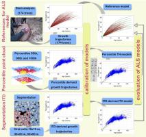
Site productivity and forest growth are critical inputs into projecting wood volume and biomass accumulation over time. Site productivity, which is determined most commonly using site index models is also the primary criterion to consider many forest management decisions. Most of the previous research utilizing the remote sensing data for assessment of site index with forest height are based on the existing site index models developed with traditional dendrometric methods. However, these traditional methods are both time-consuming and expensive. This study demonstrates how bi-temporal airborne laser scanning (ALS) data collected within the 8-year period can be used for the development of site index models for Scots pine. The accuracy of ALS-derived models was assessed by comparison to the reference site index model developed based on data from stem analysis of 174 felled Scots pine trees. We evaluated the effect of different height metrics and grid cell size on the trajectory of site index models developed from ALS-derived measurements. Four methods of estimating top height from ALS point clouds were evaluated: 95th, 99th and 100th percentiles of point clouds and an individual tree detection approach (ITD). The models were created for a range of grid cell sizes: 10 × 10 m, 30 × 30 m, and 50 × 50 m. The results indicate that bitemporal ALS data could substitute traditional methods that have been applied to date for stand growth modelling. It was found that top height increment can be estimated by using both ITD approach and the 100th percentile of point cloud giving an appropriate top height (TH) increment estimation. Observed growth curves of reference trees agreed best with the trajectories that were obtained based on TH calculated using ITD method (R2 = 0.892) and 100th percentile (R2 = 0.797). In case of TH obtained from 99th and 95th percentiles only weak correlation was found: R2 = 0.358 and R2 = 0.213, accordingly. The height growth models developed with 95th and 99th percentiles of point cloud were not compatible with the reference model. We also found that grid cell size did not affect the model height growth trajectories. Irrespective of the grid cell size, the obtained model trajectories for the given method of TH estimation are nearly identical for cells 10 × 10, 30 × 30 and 50 × 50 m.
中文翻译:
评估使用双时机载激光扫描数据开发的站点索引模型对不同的顶部高度估计和网格单元大小的敏感性
场地生产力和森林生长是预测木材量和生物量随时间推移积累的关键输入。最常使用站点索引模型确定的站点生产力也是考虑许多森林管理决策的主要标准。先前的大多数利用遥感数据评估林高的立地指数的研究都是基于利用传统测树方法开发的现有立地指数模型。但是,这些传统方法既费时又昂贵。这项研究表明,如何在8年内收集到的双时空激光扫描(ALS)数据可用于开发苏格兰松树的站点指数模型。通过与参考点索引模型进行比较,评估了ALS衍生模型的准确性,该参考点索引模型是基于对174棵砍伐的苏格兰松树的茎进行分析得出的数据。我们评估了不同高度度量和网格单元大小对根据ALS得出的测量结果开发的站点索引模型的轨迹的影响。评估了从ALS点云估计顶部高度的四种方法:点云的第95、99和100个百分位数以及单个树检测方法(ITD)。这些模型是针对一系列网格尺寸(10×10 m,30×30 m和50×50 m)创建的。结果表明,时空ALS数据可以替代迄今已用于林分生长建模的传统方法。发现可以同时使用ITD方法和点云的第100个百分位数来估计顶部高度增量,从而给出适当的顶部高度(TH)增量估计。观察到的参考树的生长曲线与使用ITD方法计算的基于TH的轨迹获得的轨迹最吻合(R2 = 0.892)和百分位数(R 2 = 0.797)。在从第99个百分位数和第95个百分位数获得TH的情况下,仅发现弱相关:R 2 = 0.358和R 2 = 0.213。使用第95和第99个百分点的点云开发的高度增长模型与参考模型不兼容。我们还发现网格单元的大小不会影响模型高度的增长轨迹。无论网格单元大小如何,对于给定的TH估计方法,对于10×10、30×30和50×50 m的单元,模型轨迹几乎相同。


 京公网安备 11010802027423号