International Journal of Disaster Risk Reduction ( IF 5 ) Pub Date : 2020-05-04 , DOI: 10.1016/j.ijdrr.2020.101638 Brian M. Tomaszewski , Elizabeth A. Moore , Kyle Parnell , Alexandra M. Leader , William R. Armington , Omar Aponte , Leslie Brooks , Brienna K. Herold , Benjamin S. Meyers , Tayler Ruggero , Zachary Sutherby , Madeline Wolters , Sandy Wu , Jörg Szarzynski , Klaus Greve , Robert Parody
|
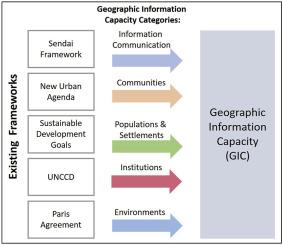
The capacity to utilize geographic information is a critical element of disaster risk management. Although access to and use of geographic information system (GIS) technology continues to grow, there remain significant gaps in approaches used by disaster risk management stakeholders to understand geographic information needs, sources, and information flow—ultimately limiting the efficacy of management efforts. To address this problem, we introduce the concept of geographic information capacity (GIC) to measure and analyze the ability of stakeholders to understand, access, and work with geographic information for disaster risk management. We propose a framework for assessing GIC, the GIC Profile, which we situate within a review of disaster risk management-relevant frameworks. We evaluate the GIC Profile using two case study countries at the first (sub-national) geo-administrative boundary level. Chi-square analyses suggest GIC across equivalent regional units within each country is relatively uniform, and that this uniformity is comparable between nations despite significant difference in overall capacity. Contributions of the GIC Profile to disaster risk management research are twofold. First, this is a first attempt to develop a profile based on key indicators for quantifying GIC highlights critical areas for capacity improvement, allowing decision makers to identify and prioritize pathways to strengthen disaster risk management programs. Through this initial effort, a decision tool has been developed which may enhance decisions on how to utilize GIS in support of disaster risk management. This tool is iterative and can be updated as new events occur to maximize GIS benefits, ultimately reducing disaster risks and their potential consequences.
中文翻译:
根据联合国框架承诺,为灾害风险管理制定地理信息能力(GIC)概况
利用地理信息的能力是灾难风险管理的关键要素。尽管对地理信息系统(GIS)技术的访问和使用不断增长,但是灾难风险管理利益相关方用来了解地理信息需求,来源和信息流的方法仍然存在巨大差距,最终限制了管理工作的有效性。为了解决此问题,我们引入了地理信息能力(GIC)的概念,以衡量和分析利益相关者理解,访问和使用地理信息进行灾害风险管理的能力。我们提出了一个评估GIC的框架,即GIC概要,我们将其置于与灾害风险管理相关的框架的审查中。我们在第一(国家以下)地理行政边界级别上使用两个案例研究国家来评估GIC概况。卡方分析表明,每个国家内同等区域单位之间的GIC相对统一,尽管整体能力存在显着差异,但各国之间的这种统一性具有可比性。GIC概要对灾难风险管理研究的贡献是双重的。首先,这是首次尝试建立基于关键指标的概要文件,以量化GIC突出显示了能力改进的关键领域,从而使决策者能够确定和优先考虑加强灾害风险管理计划的途径。通过最初的努力,开发了一种决策工具,可以增强有关如何利用的决策。卡方分析表明,每个国家内同等区域单位之间的GIC相对统一,尽管整体能力存在显着差异,但各国之间的这种统一性具有可比性。GIC概要对灾难风险管理研究的贡献是双重的。首先,这是首次尝试建立基于关键指标的概要文件,以量化GIC突出显示了能力改进的关键领域,从而使决策者能够确定和优先考虑加强灾害风险管理计划的途径。通过最初的努力,开发了一种决策工具,可以增强有关如何利用的决策。卡方分析表明,每个国家内同等区域单位之间的GIC相对统一,尽管整体能力存在显着差异,但各国之间的这种统一性具有可比性。GIC概要对灾难风险管理研究的贡献是双重的。首先,这是首次尝试建立基于关键指标的概要文件,以量化GIC突出显示了能力改进的关键领域,从而使决策者能够确定和优先考虑加强灾害风险管理计划的途径。通过最初的努力,开发了一种决策工具,可以增强有关如何利用的决策。GIC概要对灾难风险管理研究的贡献是双重的。首先,这是首次尝试建立基于关键指标的概要文件,以量化GIC突出显示了能力改进的关键领域,从而使决策者能够确定和优先考虑加强灾害风险管理计划的途径。通过最初的努力,开发了一种决策工具,可以增强有关如何利用的决策。GIC概要对灾难风险管理研究的贡献是双重的。首先,这是首次尝试建立基于关键指标的概要文件,以量化GIC强调的关键领域,以提高能力,使决策者能够确定和确定加强灾害风险管理计划的途径并确定其优先级。通过最初的努力,开发了一种决策工具,可以增强有关如何利用的决策。GIS支持灾害风险管理。该工具是迭代的,可以在发生新事件时进行更新,以最大程度地提高GIS的效益,最终减少灾难风险及其潜在后果。


 京公网安备 11010802027423号