当前位置:
X-MOL 学术
›
Earth Surf.Process. Land.
›
论文详情
Our official English website, www.x-mol.net, welcomes your feedback! (Note: you will need to create a separate account there.)
Use of terrestrial photosieving and airborne topographic LiDAR to assess bed grain size in large rivers: a study on the Rhine River
Earth Surface Processes and Landforms ( IF 3.3 ) Pub Date : 2020-06-10 , DOI: 10.1002/esp.4882 Valentin Chardon 1, 2 , Laurent Schmitt 1 , Hervé Piégay 2 , Dimitri Lague 3
Earth Surface Processes and Landforms ( IF 3.3 ) Pub Date : 2020-06-10 , DOI: 10.1002/esp.4882 Valentin Chardon 1, 2 , Laurent Schmitt 1 , Hervé Piégay 2 , Dimitri Lague 3
Affiliation
|
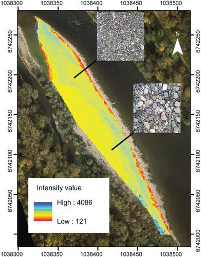
Most grain size monitoring is still being conducted by manual sampling in the field, which is time consuming and has low spatial representation. Due to new remote sensing methods, some limitations have been partly overcome, but methodological progress is still needed for large rivers as well as in underwater conditions. In this article, we tested the reliability of two methods along the Old Rhine River (France/Germany) to estimate the grain size distribution (GSD) in above‐water conditions: (i) a low‐cost terrestrial photosieving method based on an automatic procedure using Digital Grain Size (DGS) software and (ii) an airborne LiDAR topo‐bathymetric survey. We also tested the ability of terrestrial photosieving to estimate the GSD in underwater conditions. Field pebble counts were performed to compare and calibrate both methods. The results showed that the automatic procedure of terrestrial photosieving is a reliable method to estimate the GSD of sediment patches in both above‐water and underwater conditions with clean substrates. Sensitivity analyses showed that environmental conditions, including solar lighting conditions and petrographic variability, significantly influence the GSD from the automatic procedure in above‐water conditions. The presence of biofilm in underwater conditions significantly altered the GSD estimation using the automatic procedure, but the proposed manual procedure overcame this problem. The airborne LiDAR topographic survey is an accurate method to estimate the GSD of above‐water bedforms and is able to generate grain size maps. The combination of terrestrial photosieving and airborne topographic LiDAR methods is adapted to assess the GSD over several kilometers long reaches of large rivers. © 2020 John Wiley & Sons, Ltd.
中文翻译:

利用陆地光筛和机载地形LiDAR评估大型河流的河床粒径:莱茵河研究
大多数颗粒尺寸监测仍在现场通过手动采样进行,这既费时又空间表示较少。由于采用了新的遥感方法,已经部分克服了一些局限性,但是对于大河以及在水下条件下,仍然需要方法上的进步。在本文中,我们测试了沿旧莱茵河(法国/德国)的两种方法的可靠性,以估算水上条件下的粒度分布(GSD):(i)一种基于自动的低成本陆地光筛方法使用Digital Grain Size(DGS)软件和(ii)机载LiDAR拓扑测深法进行测量。我们还测试了地面光筛法在水下条件下估算GSD的能力。进行现场卵石计数以比较和校准这两种方法。结果表明,地面光筛的自动程序是一种可靠的方法,可以在干净的底物的情况下估算水上和水下条件下沉积物斑块的GSD。敏感性分析表明,环境条件,包括太阳能照明条件和岩相学变异性,会在水上条件下通过自动程序显着影响GSD。水下条件下生物膜的存在极大地改变了使用自动程序进行的GSD估算,但是建议的手动程序克服了这个问题。机载LiDAR地形勘测是估算水上床形GSD的准确方法,并且能够生成粒度图。地面光筛和机载地形LiDAR方法的组合适用于评估几公里长的大型河流的GSD。分级为4 +©2020 John Wiley&Sons,Ltd.
更新日期:2020-06-10
中文翻译:
利用陆地光筛和机载地形LiDAR评估大型河流的河床粒径:莱茵河研究
大多数颗粒尺寸监测仍在现场通过手动采样进行,这既费时又空间表示较少。由于采用了新的遥感方法,已经部分克服了一些局限性,但是对于大河以及在水下条件下,仍然需要方法上的进步。在本文中,我们测试了沿旧莱茵河(法国/德国)的两种方法的可靠性,以估算水上条件下的粒度分布(GSD):(i)一种基于自动的低成本陆地光筛方法使用Digital Grain Size(DGS)软件和(ii)机载LiDAR拓扑测深法进行测量。我们还测试了地面光筛法在水下条件下估算GSD的能力。进行现场卵石计数以比较和校准这两种方法。结果表明,地面光筛的自动程序是一种可靠的方法,可以在干净的底物的情况下估算水上和水下条件下沉积物斑块的GSD。敏感性分析表明,环境条件,包括太阳能照明条件和岩相学变异性,会在水上条件下通过自动程序显着影响GSD。水下条件下生物膜的存在极大地改变了使用自动程序进行的GSD估算,但是建议的手动程序克服了这个问题。机载LiDAR地形勘测是估算水上床形GSD的准确方法,并且能够生成粒度图。地面光筛和机载地形LiDAR方法的组合适用于评估几公里长的大型河流的GSD。分级为4 +©2020 John Wiley&Sons,Ltd.


 京公网安备 11010802027423号