当前位置:
X-MOL 学术
›
Int. J. Climatol.
›
论文详情
Our official English website, www.x-mol.net, welcomes your feedback! (Note: you will need to create a separate account there.)
A multi‐century meteo‐hydrological analysis for the Adda river basin (Central Alps). Part I: Gridded monthly precipitation (1800–2016) records
International Journal of Climatology ( IF 3.9 ) Pub Date : 2020-04-23 , DOI: 10.1002/joc.6614 Alice Crespi 1 , Michele Brunetti 2 , Roberto Ranzi 3 , Massimo Tomirotti 3 , Maurizio Maugeri 1, 2
International Journal of Climatology ( IF 3.9 ) Pub Date : 2020-04-23 , DOI: 10.1002/joc.6614 Alice Crespi 1 , Michele Brunetti 2 , Roberto Ranzi 3 , Massimo Tomirotti 3 , Maurizio Maugeri 1, 2
Affiliation
|
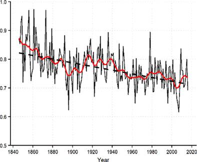
The 1800–2016 monthly precipitation record for the upper Adda river basin is presented. It is computed by applying the anomaly method to a quality‐checked and homogenized observation database. The reconstruction accuracy and its evolution over the study period is evaluated at both station and grid‐cell levels. The anomaly‐based interpolation provides rather robust estimates even for the early years of sparse station coverage with basin precipitation reconstruction errors around 10%. The Theil‐Sen trend analysis on the basin precipitation series shows significant (Mann‐Kendall p value <.05) long‐term tendencies of −3.8 ± 1.9% and −9.3 ± 3.8% century−1 for annual and autumn precipitation, respectively, even though the annual trend is not significant by excluding the first decades from the evaluation. As the basin precipitation record is expected to be underestimated due to the rain‐gauge snow undercatch, the monthly precipitation fields are subjected to a correction procedure which allows to derive the multiplicative correcting constant to be applied to the basin annual precipitation series. The comparison between 1845 and 2016 yearly corrected precipitation and runoff records highlights current annual water losses of about 400 mm while the annual runoff coefficients exhibit a long‐term significant decrease of −6.4 ± 1.0% century−1. This change in the hydrological cycle is mostly to be ascribed to the strong long‐term reduction in annual runoff values (−11.8 ± 3.2% century−1) driven by increasing evapotranspiration due to both temperature increase and, likely, land‐use changes.
中文翻译:

阿达河流域(中阿尔卑斯山)的多世纪以来的气象水文分析。第一部分:网格月降水量(1800-2016年)记录
介绍了阿达河上游流域的1800–2016月降水记录。它是通过将异常方法应用于经过质量检查和均质化的观察数据库来计算的。在站点和网格单元级别都评估了研究期间的重建精度及其演变。基于异常的插值即使在稀疏站覆盖的最初几年也提供了相当可靠的估计,盆地降水重建误差约为10%。对盆地降水序列的Theil-Sen趋势分析显示,长期趋势(Mann-Kendall p值<.05)为-3.8±1.9%和-9.3±3.8%世纪-1通过将前几十年排除在评估范围之外,即使年度趋势并不显着,也分别针对年降水量和秋季降水。由于雨量积雪的欠缺,预计流域降水记录将被低估,因此对月降水场进行校正程序,该程序可以推导适用于流域年降水量序列的乘数校正常数。1845年和2016年的年度校正降水量和径流记录之间的比较突出显示了当前每年约400毫米的水损失,而年度径流系数显示了-6.4±1.0%世纪-1的长期显着下降。水文循环的这种变化主要归因于由于温度升高和可能的土地利用变化而引起的蒸散量增加,导致年径流量值长期大幅下降(−11.8±3.2%Century -1)。
更新日期:2020-04-23
中文翻译:
阿达河流域(中阿尔卑斯山)的多世纪以来的气象水文分析。第一部分:网格月降水量(1800-2016年)记录
介绍了阿达河上游流域的1800–2016月降水记录。它是通过将异常方法应用于经过质量检查和均质化的观察数据库来计算的。在站点和网格单元级别都评估了研究期间的重建精度及其演变。基于异常的插值即使在稀疏站覆盖的最初几年也提供了相当可靠的估计,盆地降水重建误差约为10%。对盆地降水序列的Theil-Sen趋势分析显示,长期趋势(Mann-Kendall p值<.05)为-3.8±1.9%和-9.3±3.8%世纪-1通过将前几十年排除在评估范围之外,即使年度趋势并不显着,也分别针对年降水量和秋季降水。由于雨量积雪的欠缺,预计流域降水记录将被低估,因此对月降水场进行校正程序,该程序可以推导适用于流域年降水量序列的乘数校正常数。1845年和2016年的年度校正降水量和径流记录之间的比较突出显示了当前每年约400毫米的水损失,而年度径流系数显示了-6.4±1.0%世纪-1的长期显着下降。水文循环的这种变化主要归因于由于温度升高和可能的土地利用变化而引起的蒸散量增加,导致年径流量值长期大幅下降(−11.8±3.2%Century -1)。


 京公网安备 11010802027423号