当前位置:
X-MOL 学术
›
Hydrol. Process.
›
论文详情
Our official English website, www.x-mol.net, welcomes your feedback! (Note: you will need to create a separate account there.)
Quantification of sediment source contributions in two paired catchments of the Brazilian Pampa using conventional and alternative fingerprinting approaches
Hydrological Processes ( IF 3.2 ) Pub Date : 2020-05-04 , DOI: 10.1002/hyp.13768 Mirian Lago Valente 1 , José Miguel Reichert 2 , Cédric Legout 3 , Tales Tiecher 4 , Rosane Barbosa Lopes Cavalcante 5 , Olivier Evrard 6
Hydrological Processes ( IF 3.2 ) Pub Date : 2020-05-04 , DOI: 10.1002/hyp.13768 Mirian Lago Valente 1 , José Miguel Reichert 2 , Cédric Legout 3 , Tales Tiecher 4 , Rosane Barbosa Lopes Cavalcante 5 , Olivier Evrard 6
Affiliation
|
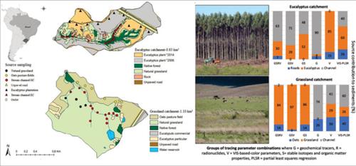
The knowledge of the contribution of sediment sources to river networks is a prerequisite to understand the impact of land use change on sediment yield. We calculated the relative contributions of sediment sources in two paired catchments, one with commercial eucalyptus plantations (0.83 km$^2$) and the other with grassland used for livestock farming (1.10 km$^2$), located in the Brazilian Pampa biome, using different combinations of conventional [geochemical (G), radionuclide (R) and stable isotopes and organic matter properties (S)] and alternative tracer properties [spectrocolorimetric visible‐based‐colour parameters (V)]. Potential sediment sources evaluated were stream channel, natural grassland and oat pasture fields in the grassland catchment, and stream channel, unpaved roads and eucalyptus plantation in the eucalyptus catchment. The results show that the best combination of tracers to discriminate the potential sources was using GSRV tracers in the grassland catchment, and using GSRV, GSV and GS tracers in the eucalyptus catchment. In all these cases, samples were 100% correctly classified in their respective groups. Considering the best tracers results (GSRV) in both catchments, the sediment source contributions estimated in the catchment with eucalyptus plantations was 63, 30 and 7% for stream channel, eucalyptus stands and unpaved roads, respectively. In the grassland catchment, the source contributions to sediment were 84, 14 and 2% for natural grassland, stream channel and oats pasture fields, respectively. The combination of these source apportionment results with the annual sediment loads monitored during a 3‐year period demonstrates that commercial eucalyptus plantations supplied approximately 10 times less sediment (0.1 ton ha$^{−1}$ year$^{−1}$) than the traditional land uses in this region, that is, 1.0 ton ha$^{−1}$ year$^{−1}$ from grassland and 0.3 ton ha$^{−1}$ year$^{−1}$ from oats pasture fields. These results demonstrate the potential of combining conventional and alternative approaches to trace sediment sources originating from different land uses in this region. Furthermore, they show that well‐managed forest plantations may be less sensitive to erosion than grassland used for intensive livestock farming, which should be taken into account to promote the sustainable use of land in this region of South America.
中文翻译:

使用传统和替代指纹识别方法量化巴西潘帕草原两个成对集水区的沉积物来源贡献
了解泥沙来源对河流网络的贡献是了解土地利用变化对泥沙产量影响的先决条件。我们计算了两个配对集水区的沉积物来源的相对贡献,一个是商业桉树种植园 (0.83 km$^2$),另一个是用于畜牧业的草地 (1.10 km$^2$),位于巴西潘帕生物群系,使用传统 [地球化学 (G)、放射性核素 (R) 和稳定同位素和有机物质特性 (S)] 和替代示踪剂特性 [光谱色度可见光颜色参数 (V)] 的不同组合。评估的潜在沉积物来源是草地集水区的河道、天然草地和燕麦牧场,以及桉树集水区的河道、未铺砌的道路和桉树种植园。结果表明,区分潜在来源的示踪剂的最佳组合是在草地集水区使用 GSRV 示踪剂,在桉树集水区使用 GSRV、GSV 和 GS 示踪剂。在所有这些情况下,样本被 100% 正确分类到各自的组中。考虑到两个流域的最佳示踪结果 (GSRV),估计在有桉树种植园的流域中,河道、桉树林分和未铺砌道路的沉积物来源贡献分别为 63%、30% 和 7%。在草地集水区,天然草地、河道和燕麦牧场对沉积物的来源贡献分别为84%、14%和2%。将这些源分配结果与 3 年期间监测的年度沉积物负荷相结合,表明商业桉树种植园提供的沉积物少约 10 倍(0.1 吨 ha$^{−1}$ year$^{−1}$)与该地区的传统土地利用相比,即 1.0 吨 ha$^{−1}$ year$^{−1}$ 来自草地和 0.3 吨 ha$^{−1}$ year$^{−1} $来自燕麦牧场。这些结果证明了结合传统方法和替代方法来追踪源自该地区不同土地用途的沉积物来源的潜力。此外,他们表明管理良好的人工林对侵蚀的敏感性可能低于用于集约化畜牧业的草地,应考虑到这一点,以促进南美洲该地区土地的可持续利用。
更新日期:2020-05-04
中文翻译:
使用传统和替代指纹识别方法量化巴西潘帕草原两个成对集水区的沉积物来源贡献
了解泥沙来源对河流网络的贡献是了解土地利用变化对泥沙产量影响的先决条件。我们计算了两个配对集水区的沉积物来源的相对贡献,一个是商业桉树种植园 (0.83 km$^2$),另一个是用于畜牧业的草地 (1.10 km$^2$),位于巴西潘帕生物群系,使用传统 [地球化学 (G)、放射性核素 (R) 和稳定同位素和有机物质特性 (S)] 和替代示踪剂特性 [光谱色度可见光颜色参数 (V)] 的不同组合。评估的潜在沉积物来源是草地集水区的河道、天然草地和燕麦牧场,以及桉树集水区的河道、未铺砌的道路和桉树种植园。结果表明,区分潜在来源的示踪剂的最佳组合是在草地集水区使用 GSRV 示踪剂,在桉树集水区使用 GSRV、GSV 和 GS 示踪剂。在所有这些情况下,样本被 100% 正确分类到各自的组中。考虑到两个流域的最佳示踪结果 (GSRV),估计在有桉树种植园的流域中,河道、桉树林分和未铺砌道路的沉积物来源贡献分别为 63%、30% 和 7%。在草地集水区,天然草地、河道和燕麦牧场对沉积物的来源贡献分别为84%、14%和2%。将这些源分配结果与 3 年期间监测的年度沉积物负荷相结合,表明商业桉树种植园提供的沉积物少约 10 倍(0.1 吨 ha$^{−1}$ year$^{−1}$)与该地区的传统土地利用相比,即 1.0 吨 ha$^{−1}$ year$^{−1}$ 来自草地和 0.3 吨 ha$^{−1}$ year$^{−1} $来自燕麦牧场。这些结果证明了结合传统方法和替代方法来追踪源自该地区不同土地用途的沉积物来源的潜力。此外,他们表明管理良好的人工林对侵蚀的敏感性可能低于用于集约化畜牧业的草地,应考虑到这一点,以促进南美洲该地区土地的可持续利用。


 京公网安备 11010802027423号