当前位置:
X-MOL 学术
›
Basin Res.
›
论文详情
Our official English website, www.x-mol.net, welcomes your feedback! (Note: you will need to create a separate account there.)
Geological mapping reveals the role of Early Jurassic rift architecture in the dispersal of calciturbidites: new insights from the Central and Northern Apennines
Basin Research ( IF 3.2 ) Pub Date : 2020-02-26 , DOI: 10.1111/bre.12438 Angelo Cipriani 1 , Martina Caratelli 2 , Massimo Santantonio 1
Basin Research ( IF 3.2 ) Pub Date : 2020-02-26 , DOI: 10.1111/bre.12438 Angelo Cipriani 1 , Martina Caratelli 2 , Massimo Santantonio 1
Affiliation
|
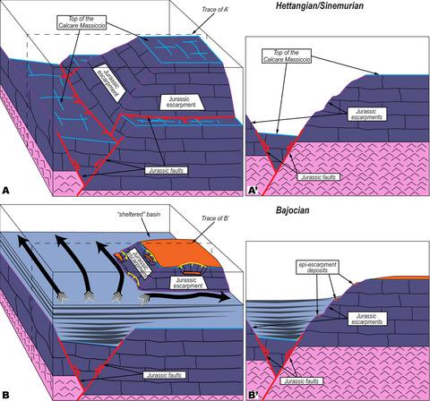
[Abstract The role of sea‐bottom topography in the dispersal of shallow water‐derived calciturbidites across a submarine rift, as determined by the local extensional architecture, is under‐investigated, namely with pelagic settings along ancient passive continental margins. A comparison with modern carbonate platform/basin analogues, or with siliciclastic systems, is not always feasible, as ancient carbonate systems were commonly home to anachronistic environments (e.g. the Western Tethyan Mesozoic). Our study focuses on: (a) a reconstruction of the palaeotectonic architecture of the Umbria‐Marche Basin in the Jurassic and on (b) how this architecture produced a submarine topography which governed the dispersal of sediment, shed by the neighbouring Lazio‐Abruzzo Carbonate Platform, for >40 million years. A geological mapping project was performed in the Apennines of Central Italy, a region which in the Jurassic displayed a pattern of intrabasinal highs (pelagic carbonate platforms) and intervening basins which was exceedingly complex due to the high density, and oddly variable trends, of faults rooted in a shallow detachment layer corresponding to thick Triassic salt. A map pairing the occurrences of these resedimented beds with an updated palaeogeography becomes the natural descriptor of the itineraries followed by sediment gravity flows. This qualitative method represents a companion, or even alternative, approach to the one strictly based on physical stratigraphy, and it greatly improves our knowledge of regional geology and rift‐basin analysis. Our case history potentially represents the analogue of hydrocarbon fields both inland and in the offshore. Geological mapping shows that the marginal palaeoescarpments of pelagic carbonate platforms formed obstacles to the gravity flows as sediment load was discharged at their toes. While turbidity flows were locally vigorous enough to climb the escarpments, leaving overbank deposits on the pelagic carbonate platform‐tops, a ‘shelter’ effect is evidenced by the resediment‐free nature of those basins lying downflow, which were shielded by the highs., 3D (A, B) and 2D (A’, B’) block diagrams illustrating: A‐A’) a hypothetic extensional structure, with stripped‐off post‐Calcare Massiccio sediments, and B‐B’) the possible pathways (dark arrows) of allochthonous shallow‐water material in a pelagic carbonate platform/marginal step/basin depositional system. Not to scale. ]
中文翻译:

地质图揭示了早侏罗世裂谷结构在方解石浊积岩扩散中的作用:来自中亚平宁山脉和北部亚平宁山脉的新见解
[摘要] 由局部伸展结构决定的海底地形在浅水衍生的钙质浊积岩穿过海底裂谷扩散中的作用尚未得到充分研究,即古代被动大陆边缘的远洋环境。与现代碳酸盐台地/盆地类似物或硅质碎屑系统的比较并不总是可行的,因为古代碳酸盐系统通常是不合时宜的环境(例如西特提斯中生代)的所在地。我们的研究重点是:(a) 重建侏罗纪翁布里亚-马尔什盆地的古构造结构,以及 (b) 这种结构如何产生海底地形,控制沉积物的扩散,由邻近的拉齐奥-阿布鲁佐碳酸盐岩脱落平台,超过 4000 万年。在意大利中部的亚平宁山脉进行了地质测绘项目,该地区在侏罗纪显示出盆地内高地(远洋碳酸盐台地)和中间盆地的模式,由于断层的高密度和奇怪的变化趋势,这些盆地非常复杂植根于与厚三叠纪盐相对应的浅脱离层。将这些再沉积床的出现与更新的古地理配对的地图成为路线的自然描述,随后是沉积物重力流。这种定性方法代表了严格基于物理地层学的方法的配套方法,甚至是替代方法,它极大地提高了我们对区域地质学和裂谷盆地分析的认识。我们的案例历史可能代表内陆和近海油气田的类比。地质填图表明,由于沉积物负荷在其趾部排出,远洋碳酸盐台地的边缘古陡坡对重力流形成了障碍。虽然局部浑浊流足以爬上悬崖,在远洋碳酸盐平台顶部留下溢流沉积物,但“庇护所”效应由位于下游的那些盆地的无沉积物性质证明,这些盆地被高位屏蔽。 3D (A, B) 和 2D (A', B') 框图说明:A-A') 一个假设的伸展结构,具有剥离的后 Calcare Massiccio 沉积物,和 B-B') 远洋碳酸盐台地/边缘台阶/盆地沉积系统中外来浅水物质的可能途径(暗箭头)。不按比例。]
更新日期:2020-02-26
中文翻译:
地质图揭示了早侏罗世裂谷结构在方解石浊积岩扩散中的作用:来自中亚平宁山脉和北部亚平宁山脉的新见解
[摘要] 由局部伸展结构决定的海底地形在浅水衍生的钙质浊积岩穿过海底裂谷扩散中的作用尚未得到充分研究,即古代被动大陆边缘的远洋环境。与现代碳酸盐台地/盆地类似物或硅质碎屑系统的比较并不总是可行的,因为古代碳酸盐系统通常是不合时宜的环境(例如西特提斯中生代)的所在地。我们的研究重点是:(a) 重建侏罗纪翁布里亚-马尔什盆地的古构造结构,以及 (b) 这种结构如何产生海底地形,控制沉积物的扩散,由邻近的拉齐奥-阿布鲁佐碳酸盐岩脱落平台,超过 4000 万年。在意大利中部的亚平宁山脉进行了地质测绘项目,该地区在侏罗纪显示出盆地内高地(远洋碳酸盐台地)和中间盆地的模式,由于断层的高密度和奇怪的变化趋势,这些盆地非常复杂植根于与厚三叠纪盐相对应的浅脱离层。将这些再沉积床的出现与更新的古地理配对的地图成为路线的自然描述,随后是沉积物重力流。这种定性方法代表了严格基于物理地层学的方法的配套方法,甚至是替代方法,它极大地提高了我们对区域地质学和裂谷盆地分析的认识。我们的案例历史可能代表内陆和近海油气田的类比。地质填图表明,由于沉积物负荷在其趾部排出,远洋碳酸盐台地的边缘古陡坡对重力流形成了障碍。虽然局部浑浊流足以爬上悬崖,在远洋碳酸盐平台顶部留下溢流沉积物,但“庇护所”效应由位于下游的那些盆地的无沉积物性质证明,这些盆地被高位屏蔽。 3D (A, B) 和 2D (A', B') 框图说明:A-A') 一个假设的伸展结构,具有剥离的后 Calcare Massiccio 沉积物,和 B-B') 远洋碳酸盐台地/边缘台阶/盆地沉积系统中外来浅水物质的可能途径(暗箭头)。不按比例。]


 京公网安备 11010802027423号