当前位置:
X-MOL 学术
›
WIREs Clim. Chang.
›
论文详情
Our official English website, www.x-mol.net, welcomes your feedback! (Note: you will need to create a separate account there.)
Assessing precipitation trends in the Americas with historical data: A review
WIREs Climate Change ( IF 9.2 ) Pub Date : 2019-11-10 , DOI: 10.1002/wcc.627 Leila M. V. Carvalho 1
WIREs Climate Change ( IF 9.2 ) Pub Date : 2019-11-10 , DOI: 10.1002/wcc.627 Leila M. V. Carvalho 1
Affiliation
|
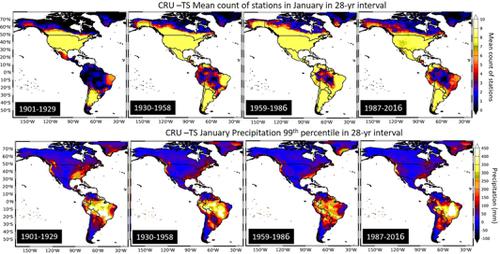
North, Central, and South America (collectively referred to as the Americas) extend across two hemispheres, and together cover approximately 28% of Earth's land area and are home to about 13% of the world's population. Unique ecosystems, diversified cultures, and communities that inhabit the region rely on precipitation delivered yearly by multiple systems, including mid‐latitudes storms, the North and South American Monsoons, and tropical storms and hurricanes. The rapid warming of the Earth's atmosphere and oceans combined with internal variability of the climate system, have modified precipitation patterns from the tropics to high latitudes. In the Americas, instrumental records have shown evidence of upward trends in extreme precipitation (amount, intensity, and frequency) in many areas. The most consistent evidence of precipitation trends occurs in mid‐latitudes of North America and in the subtropics of South America. Recent studies have indicated a poleward shift of heavy precipitation associated with South American Monsoon. Nonetheless, the deficient network of rain gauges in vast areas over tropical Americas limits the assessment of trends in regions with heavy rainfall amounts. Additionally, observed trends in the North America monsoon precipitation are difficult to separate from the contribution of tropical storms and hurricanes. Furthermore, coupled modes such as the El Nino/Southern Oscillation, the Pacific Decadal Oscillation, and the Atlantic Multidecadal Oscillation modulate precipitation in the Americas, from the tropics to the extratropics, and these teleconnections are relevant to assess precipitation trends using historical records. This review evaluates all these complex issues focusing on observations based on instrumental datasets.
中文翻译:

利用历史数据评估美洲的降水趋势:回顾
北美,中美洲和南美洲(统称为美洲)横跨两个半球,共同覆盖地球约28%的土地面积,约占世界人口的13%。居住在该地区的独特生态系统,多元文化和社区依赖于每年通过多种系统提供的降水,其中包括中纬度风暴,北美和南美季风以及热带风暴和飓风。地球大气和海洋的迅速变暖,加上气候系统的内部变化,已经改变了从热带到高纬度地区的降水模式。在美洲,仪器记录显示出许多地区极端降水(数量,强度和频率)呈上升趋势的证据。降水趋势的最一致证据出现在北美中纬度和南美亚热带。最近的研究表明,与南美季风有关的强降水向极移。然而,热带美洲广大地区雨量计网络的不足限制了对降雨量大的地区趋势的评估。此外,北美季风降水的观测趋势很难与热带风暴和飓风的影响区分开。此外,诸如厄尔尼诺/南方涛动,太平洋年代际涛动和大西洋多年代际涛动等耦合模式调节了从热带到温带的美洲降水,这些遥相关与使用历史记录评估降水趋势有关。这篇综述评估了所有这些复杂的问题,重点是基于仪器数据集的观测。
更新日期:2019-11-10
中文翻译:
利用历史数据评估美洲的降水趋势:回顾
北美,中美洲和南美洲(统称为美洲)横跨两个半球,共同覆盖地球约28%的土地面积,约占世界人口的13%。居住在该地区的独特生态系统,多元文化和社区依赖于每年通过多种系统提供的降水,其中包括中纬度风暴,北美和南美季风以及热带风暴和飓风。地球大气和海洋的迅速变暖,加上气候系统的内部变化,已经改变了从热带到高纬度地区的降水模式。在美洲,仪器记录显示出许多地区极端降水(数量,强度和频率)呈上升趋势的证据。降水趋势的最一致证据出现在北美中纬度和南美亚热带。最近的研究表明,与南美季风有关的强降水向极移。然而,热带美洲广大地区雨量计网络的不足限制了对降雨量大的地区趋势的评估。此外,北美季风降水的观测趋势很难与热带风暴和飓风的影响区分开。此外,诸如厄尔尼诺/南方涛动,太平洋年代际涛动和大西洋多年代际涛动等耦合模式调节了从热带到温带的美洲降水,这些遥相关与使用历史记录评估降水趋势有关。这篇综述评估了所有这些复杂的问题,重点是基于仪器数据集的观测。


 京公网安备 11010802027423号