当前位置:
X-MOL 学术
›
Ecol. Eng.
›
论文详情
Our official English website, www.x-mol.net, welcomes your feedback! (Note: you will need to create a separate account there.)
Large-scale flood hazard assessment under climate change: A case study
Ecological Engineering ( IF 3.8 ) Pub Date : 2020-03-01 , DOI: 10.1016/j.ecoleng.2020.105765 Amirhossein Shadmehri Toosi , Shahab Doulabian , Erfan Ghasemi Tousi , Giancarlo Humberto Calbimonte , Sina Alaghmand
Ecological Engineering ( IF 3.8 ) Pub Date : 2020-03-01 , DOI: 10.1016/j.ecoleng.2020.105765 Amirhossein Shadmehri Toosi , Shahab Doulabian , Erfan Ghasemi Tousi , Giancarlo Humberto Calbimonte , Sina Alaghmand
|
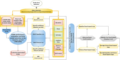
Abstract Climate change represents a set of mechanisms that result in significant impacts toward hydrologic processes both at global and regional scales and usually they are developing countries where face the most challenging consequences. For instance, arid and semi-arid environments experience a high level of uncertainty in rainfall, which results in unforeseen periods of droughts, or high-intensity rainfall, which generates severe floods, increasing the water insecurity and flood damage in these areas. Climate pattern variations are specifically critical to forecast conditions for flood hazard management. General Circulation Models (GCMs) are useful tools to forecast future climate change scenarios. However, the application of GCM in flood hazard management is particularly challenging, given that they operate under high uncertainty and coarse scale. In this context, a five-class Flood Hazard Index (FHI) map was generated by using a multi criteria index approach, based on defining the greater influence of seven factors related to flood generation: runoff coefficient, elevation, slope, distance from the drainage network, rainfall intensity, soil erosion and land use. In this paper, we utilized monthly data for the baseline period (1980–2004), and then the output of 8 GCMs for surface air temperature (SAT) and precipitation were downscaled using a statistical model and evaluated in the baseline period. Consequently, the most suitable models were selected according to their average monthly performance. The Soil and Water Assessment Tool (SWAT) was then used to develop a runoff coefficient map, using the downscaled outputs of the selected GCMs. Accordingly, a flood hazard model was developed at a large basin in the northeast of Iran for baseline and future periods (2040–2064) under RCP 8.5 emission scenarios. Having validated the generated flood map for the baseline period, the future maps were generated and compared. Results show the increase in temperature and decrease in precipitation; however, it was found that rainfall intensities are to be increased. This supports the final flood hazard map for the future climate conditions scenario with an increased relative hazard level. This was particularly observed in flat, and moderate sloped areas, compared to the model results with historic climate data.
更新日期:2020-03-01


 京公网安备 11010802027423号