Estuaries and Coasts ( IF 2.7 ) Pub Date : 2020-02-04 , DOI: 10.1007/s12237-020-00707-2 Agnes Mittermayr , Bryan Legare , Mark Borrelli
|
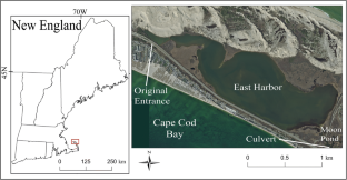
The Coastal and Marine Ecological Classification Standard (CMECS) was used to create standardized maps of habitats and biotopes by combining CMECS’s four stand-alone components: Geoform, Substrate, Biotic, and Water, based on data collected in a shallow New England salt marsh lagoon. East Harbor on Cape Cod, MA, USA, was artificially isolated from tidal flow in the late 1860s. Consequently, estuarine fish and invertebrate populations declined until partial tidal flow was restored in 2002. In early September 2017, we conducted an acoustic survey covering 1.29 km2 (mean depth = 1.27 m) of East Harbor using a vessel mounted phase measuring sidescan sonar. From the acoustic survey data, submerged aquatic vegetation (SAV) was mapped and used for a stratified random sampling scheme. On 2 days in late September 2017, East Harbor was sampled for benthic invertebrates, sediment, and water properties (pH, dissolved oxygen, salinity, and temperature) at sixteen stations (eight bare substrates and eight SAV). As the restoration project develops over time from a newly restored (2002) to a more fully restored (2017) system, links between abiotic and biotic components strengthen. Consequently, we were able to explain 89.39% of species distribution in East Harbor using measured abiotic variables (e.g., sediment characteristics) and show the diminishing influence of “distance to culvert” in explaining species distribution in East Harbor.
中文翻译:
沿海和海洋生态分类标准 (CMECS) 在部分修复的新英格兰盐沼泻湖中的应用
沿海和海洋生态分类标准 (CMECS) 用于根据在新英格兰浅盐沼泻湖中收集的数据,结合 CMECS 的四个独立组件:Geoform、Substrate、Biotic 和 Water,创建栖息地和生物群落的标准化地图. 美国马萨诸塞州科德角的东港在 1860 年代后期被人为地与潮汐流隔离开来。因此,河口鱼类和无脊椎动物种群数量下降,直到 2002 年部分潮汐流恢复。2017 年 9 月上旬,我们进行了覆盖 1.29 km 2的声学调查东港(平均深度 = 1.27 m)使用船载相位测量侧扫声纳。从声学调查数据中,被淹没的水生植被 (SAV) 被绘制并用于分层随机抽样方案。2017 年 9 月下旬的 2 天,东港在 16 个站点(8 个裸露的基质和 8 个 SAV)对底栖无脊椎动物、沉积物和水的特性(pH、溶解氧、盐度和温度)进行了采样。随着恢复项目从新恢复(2002 年)到更完全恢复(2017 年)系统的发展,非生物和生物成分之间的联系得到加强。因此,我们能够使用测量的非生物变量(例如,


 京公网安备 11010802027423号