当前位置:
X-MOL 学术
›
Mar. Petrol. Geol.
›
论文详情
Our official English website, www.x-mol.net, welcomes your feedback! (Note: you will need to create a separate account there.)
Sediment transport mechanisms revealed by quantitative analyses of seafloor morphology: New evidence from multibeam bathymetry of the Israel exclusive economic zone
Marine and Petroleum Geology ( IF 4.2 ) Pub Date : 2020-04-01 , DOI: 10.1016/j.marpetgeo.2020.104224 Mor Kanari , Gideon Tibor , John K. Hall , Tomer Ketter , Guy Lang , Uri Schattner
Marine and Petroleum Geology ( IF 4.2 ) Pub Date : 2020-04-01 , DOI: 10.1016/j.marpetgeo.2020.104224 Mor Kanari , Gideon Tibor , John K. Hall , Tomer Ketter , Guy Lang , Uri Schattner
|
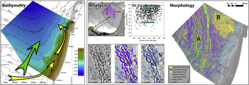
Abstract This study synthesizes 15 years (2001–2016) of detailed multibeam hydrographic mapping covering the entire 26,500 km2 of the Israeli Exclusive Economic Zone (EEZ). Multibeam data were collected on-board three research vessels across the continental shelf, slope, and the deep Levant basin; between water depths of about 15 m to 2100 m. Single-channel 3.5 kHz seismic reflection chirp profiles were collected simultaneously with the multibeam surveys in selected parts of the area. The new data enabled the first comprehensive quantitative seafloor morphological analysis of the slope and deep basin. Using GIS techniques on the high-resolution multibeam data, we analyze the spatial distribution and quantitatively describe the seafloor morphologies in detail. High-resolution chirp seismic profiles demonstrate the underlying shallow structure. Results indicate that the seabed comprises five main morphologies: folds, faults, sediment waves, deepwater channels, and sediment fan lobes. Quantitative morphological analysis and seismic data interpretation were used to derive field relations between these morphologies, which along with previously collected multi-channel seismic reflection data, suggest that a concentric fold geometry formed around the Nile outlet during the late Pliocene to early Pleistocene, as part of a general thin-skin radial salt-tectonic deformation above the Messinian mobile unit. This radial motion was accompanied by displacement along NNE-trending strike-slip faults in the basin, and an extensional component across E-W trending strike-slip faults along the Levant margin. While some of these displacements continue to deform the modern seabed (across Area A), others are covered by a wedge of Quaternary deposits, mainly in the northeastern part of the basin (Area B). Areas A and B also differ in grain size distribution, as indicated by backscatter analysis of the multibeam data. These observations divide the Israeli EEZ into two distinct areas: (Area A) Nile derived siliciclastic sediments transported directly into the deep basin via confined (forming meandering channels and overbank deposits) and unconfined flows (forming fans and lobes). The wedge consisting of Area B was fed by erosion products of the Nile outlet that were transported northwards along the continental shelf by seafloor currents of the Levant Jet System, and glided down the northern Levant continental slope as turbidity currents. This supply built at least seven sequences of Quaternary sediment waves that form upslope migrating cyclic steps. The complete data coverage and quantitative morphological analysis presented here introduce new spatial and temporal constraints that call for a reexamination of previous seabed sampling locations not accounting for detailed bathymetry, and to augment future seabed sampling efforts, understanding the sediment supply paths across the basin, and the geomorphological footprint of salt tectonics processes.
中文翻译:

海底形态定量分析揭示的沉积物运输机制:来自以色列专属经济区多波束测深的新证据
摘要 本研究综合了 15 年(2001-2016)详细的多波束水文测绘,覆盖了以色列专属经济区 (EEZ) 的整个 26,500 平方公里。在横跨大陆架、斜坡和黎凡特深海盆地的三艘研究船上收集了多波束数据;水深约 15 m 至 2100 m 之间。单通道 3.5 kHz 地震反射线性调频剖面与该地区选定部分的多波束勘测同时收集。新数据实现了对斜坡和深盆的首次全面定量海底形态分析。在高分辨率多波束数据上使用 GIS 技术,我们分析了空间分布并详细地定量描述了海底形态。高分辨率 chirp 地震剖面显示了底层的浅层结构。结果表明,海底包括五种主要形态:褶皱、断层、沉积波、深水通道和沉积扇叶。定量形态分析和地震数据解释用于推导这些形态之间的场关系,连同先前收集的多道地震反射数据,表明在上新世晚期至更新世早期,尼罗河出口周围形成了同心褶皱几何形状,作为一部分墨西拿移动单元上方的一般薄皮径向盐构造变形。这种径向运动伴随着盆地内沿 NNE 向走滑断层的位移,以及沿黎凡特边缘跨越 EW 向走滑断层的伸展分量。虽然其中一些位移继续使现代海床变形(跨区域 A),其他的被第四纪沉积物覆盖,主要位于盆地的东北部(B 区)。多光束数据的反向散射分析表明,区域 A 和 B 的晶粒尺寸分布也不同。这些观察结果将以色列专属经济区划分为两个不同的区域:(A 区)尼罗河衍生的硅质碎屑沉积物通过承压(形成蜿蜒通道和堤岸沉积物)和无承压流(形成扇形和裂片)直接输送到深盆中。由 B 区组成的楔形由尼罗河出口的侵蚀产物供给,这些侵蚀产物被黎凡特喷流系统的海底流沿大陆架向北输送,并作为浊流沿着黎凡特北部大陆坡滑下。这种供应建立了至少七个第四纪沉积波序列,形成了上坡迁移的循环台阶。此处提供的完整数据覆盖范围和定量形态分析引入了新的空间和时间限制,要求重新检查以前未考虑详细水深测量的海底采样位置,并加强未来的海底采样工作,了解整个盆地的沉积物供应路径,以及盐构造过程的地貌足迹。
更新日期:2020-04-01
中文翻译:
海底形态定量分析揭示的沉积物运输机制:来自以色列专属经济区多波束测深的新证据
摘要 本研究综合了 15 年(2001-2016)详细的多波束水文测绘,覆盖了以色列专属经济区 (EEZ) 的整个 26,500 平方公里。在横跨大陆架、斜坡和黎凡特深海盆地的三艘研究船上收集了多波束数据;水深约 15 m 至 2100 m 之间。单通道 3.5 kHz 地震反射线性调频剖面与该地区选定部分的多波束勘测同时收集。新数据实现了对斜坡和深盆的首次全面定量海底形态分析。在高分辨率多波束数据上使用 GIS 技术,我们分析了空间分布并详细地定量描述了海底形态。高分辨率 chirp 地震剖面显示了底层的浅层结构。结果表明,海底包括五种主要形态:褶皱、断层、沉积波、深水通道和沉积扇叶。定量形态分析和地震数据解释用于推导这些形态之间的场关系,连同先前收集的多道地震反射数据,表明在上新世晚期至更新世早期,尼罗河出口周围形成了同心褶皱几何形状,作为一部分墨西拿移动单元上方的一般薄皮径向盐构造变形。这种径向运动伴随着盆地内沿 NNE 向走滑断层的位移,以及沿黎凡特边缘跨越 EW 向走滑断层的伸展分量。虽然其中一些位移继续使现代海床变形(跨区域 A),其他的被第四纪沉积物覆盖,主要位于盆地的东北部(B 区)。多光束数据的反向散射分析表明,区域 A 和 B 的晶粒尺寸分布也不同。这些观察结果将以色列专属经济区划分为两个不同的区域:(A 区)尼罗河衍生的硅质碎屑沉积物通过承压(形成蜿蜒通道和堤岸沉积物)和无承压流(形成扇形和裂片)直接输送到深盆中。由 B 区组成的楔形由尼罗河出口的侵蚀产物供给,这些侵蚀产物被黎凡特喷流系统的海底流沿大陆架向北输送,并作为浊流沿着黎凡特北部大陆坡滑下。这种供应建立了至少七个第四纪沉积波序列,形成了上坡迁移的循环台阶。此处提供的完整数据覆盖范围和定量形态分析引入了新的空间和时间限制,要求重新检查以前未考虑详细水深测量的海底采样位置,并加强未来的海底采样工作,了解整个盆地的沉积物供应路径,以及盐构造过程的地貌足迹。


 京公网安备 11010802027423号