Our official English website, www.x-mol.net, welcomes your feedback! (Note: you will need to create a separate account there.)
Water input into the Mariana subduction zone estimated from ocean-bottom seismic data
Nature ( IF 64.8 ) Pub Date : 2018-11-01 , DOI: 10.1038/s41586-018-0655-4 Chen Cai , Douglas A. Wiens , Weisen Shen , Melody Eimer
Nature ( IF 64.8 ) Pub Date : 2018-11-01 , DOI: 10.1038/s41586-018-0655-4 Chen Cai , Douglas A. Wiens , Weisen Shen , Melody Eimer
|
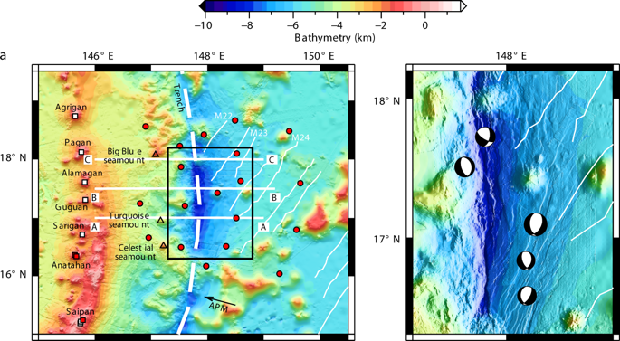
The water cycle at subduction zones remains poorly understood, although subduction is the only mechanism for water transport deep into Earth. Previous estimates of water flux1–3 exhibit large variations in the amount of water that is subducted deeper than 100 kilometres. The main source of uncertainty in these calculations is the initial water content of the subducting uppermost mantle. Previous active-source seismic studies suggest that the subducting slab may be pervasively hydrated in the plate-bending region near the oceanic trench4–7. However, these studies do not constrain the depth extent of hydration and most investigate young incoming plates, leaving subduction-zone water budgets for old subducting plates uncertain. Here we present seismic images of the crust and uppermost mantle around the central Mariana trench derived from Rayleigh-wave analysis of broadband ocean-bottom seismic data. These images show that the low mantle velocities that result from mantle hydration extend roughly 24 kilometres beneath the Moho discontinuity. Combined with estimates of subducting crustal water, these results indicate that at least 4.3 times more water subducts than previously calculated for this region3. If other old, cold subducting slabs contain correspondingly thick layers of hydrous mantle, as suggested by the similarity of incoming plate faulting across old, cold subducting slabs, then estimates of the global water flux into the mantle at depths greater than 100 kilometres must be increased by a factor of about three compared to previous estimates3. Because a long-term net influx of water to the deep interior of Earth is inconsistent with the geological record8, estimates of water expelled at volcanic arcs and backarc basins probably also need to be revised upwards9.Seismic images of Earth’s crust and uppermost mantle around the Mariana trench show widespread serpentinization, suggesting that much more water is subducted than previously thought.
中文翻译:

从海底地震数据估计的马里亚纳俯冲带的水输入
俯冲带的水循环仍然知之甚少,尽管俯冲是水输送到地球深处的唯一机制。先前对水通量 1-3 的估计表明,俯冲深度超过 100 公里的水量变化很大。这些计算中不确定性的主要来源是俯冲最上地幔的初始含水量。先前的活动源地震研究表明,俯冲板片可能在海沟附近的板块弯曲区普遍存在水合4-7。然而,这些研究并没有限制水化的深度范围,并且大多数研究年轻的进入板块,使得旧俯冲板块的俯冲带水收支不确定。在这里,我们展示了从宽带海底地震数据的瑞利波分析得出的中央马里亚纳海沟周围地壳和最上地幔的地震图像。这些图像显示,地幔水合导致的低地幔速度在莫霍面不连续面下方延伸约 24 公里。结合对俯冲地壳水的估计,这些结果表明,该地区的水俯冲至少是先前计算的 4.3 倍。如果其他旧的冷俯冲板块包含相应厚的含水地幔层,正如进入板块断层穿过旧的冷俯冲板块的相似性所暗示的那样,那么必须增加对深度大于 100 公里的地幔的全球水通量的估计与之前的估计相比,增加了大约三倍3。
更新日期:2018-11-01
中文翻译:
从海底地震数据估计的马里亚纳俯冲带的水输入
俯冲带的水循环仍然知之甚少,尽管俯冲是水输送到地球深处的唯一机制。先前对水通量 1-3 的估计表明,俯冲深度超过 100 公里的水量变化很大。这些计算中不确定性的主要来源是俯冲最上地幔的初始含水量。先前的活动源地震研究表明,俯冲板片可能在海沟附近的板块弯曲区普遍存在水合4-7。然而,这些研究并没有限制水化的深度范围,并且大多数研究年轻的进入板块,使得旧俯冲板块的俯冲带水收支不确定。在这里,我们展示了从宽带海底地震数据的瑞利波分析得出的中央马里亚纳海沟周围地壳和最上地幔的地震图像。这些图像显示,地幔水合导致的低地幔速度在莫霍面不连续面下方延伸约 24 公里。结合对俯冲地壳水的估计,这些结果表明,该地区的水俯冲至少是先前计算的 4.3 倍。如果其他旧的冷俯冲板块包含相应厚的含水地幔层,正如进入板块断层穿过旧的冷俯冲板块的相似性所暗示的那样,那么必须增加对深度大于 100 公里的地幔的全球水通量的估计与之前的估计相比,增加了大约三倍3。


 京公网安备 11010802027423号