International Journal of Applied Earth Observation and Geoinformation ( IF 7.5 ) Pub Date : 2018-10-03 , DOI: 10.1016/j.jag.2018.09.018 F. Foroughnia , S. Nemati , Y. Maghsoudi , D. Perissin
|
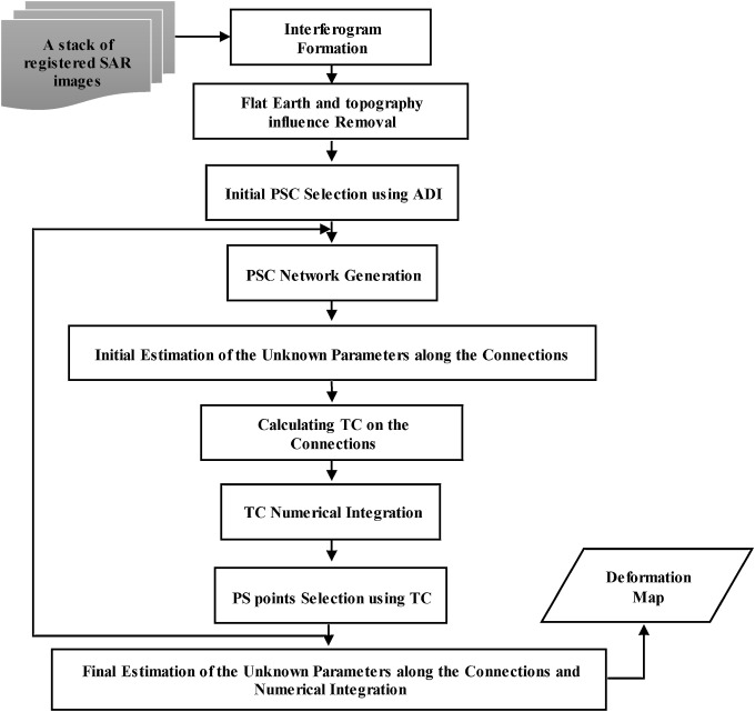
South-west of Tehran, the capital city of Iran, is subjected to a high deformation rate due to excessive groundwater extractions. Persistent Scatterrer SAR Interferometry (PS-InSAR) technique is used to monitor Tehran’s deformation. Three time series data including two Sentinel-1A (S-1A) spanning from 2014 to 2017, and an ENVISAT-ASAR data stack spanning from 2004 to 2010, are analyzed. The PS-InSAR technique does not perform well on ENVISAT-ASAR due to poor selection of PS points induced by large perpendicular baselines and strong temporal decorrelation of the dataset. In this paper, a novel Iterative PSI method (IPSI) is proposed to increase the PS points which are lost in PS-InSAR technique because of the unsuccessful derivation of the absolute phase value due to an integer ambiguity. The method selects PS points based on simultaneous analysis of their amplitude and phase. Results demonstrate that the density of PSs has been increased by about 4.5 times. Line of Sight (LOS) velocities obtained from both S-1A and ENVISAT-ASAR data analysis are highly compatible with each other, indicating the reliability of the both applied methods. The maximum cumulative displacements are estimated as 39.6 cm and 88.4 cm for Sentinel-1A and ENVISAT-ASAR datasets respectively. Moreover, the subsidence area has grown in the period between the data acquisition time. The methods are successfully validated by subsidence rates obtained from precise leveling and GPS observations.
中文翻译:
迭代PS-InSAR方法用于分析大型时空基线数据栈以进行地面沉降估算
伊朗首都德黑兰的西南部,由于地下水开采过多,变形率很高。持久散射体SAR干涉测量(PS-InSAR)技术用于监视德黑兰的形变。分析了三个时间序列数据,其中包括2014年至2017年的两个Sentinel-1A(S-1A)以及2004年至2010年的ENVISAT-ASAR数据堆栈。PS-InSAR技术在ENVISAT-ASAR上表现不佳,原因是较大的垂直基线和强大的数据时间相关性导致PS点选择不佳。在本文中,提出了一种新颖的迭代PSI方法(IPSI),以增加PS-InSAR技术中丢失的PS点,这是由于整数模糊性导致无法成功推导出绝对相位值。该方法基于对PS点的幅度和相位的同步分析来选择它们。结果表明,PS的密度增加了约4.5倍。从S-1A和ENVISAT-ASAR数据分析获得的视线(LOS)速度彼此高度兼容,表明这两种应用方法的可靠性。对于Sentinel-1A和ENVISAT-ASAR数据集,最大累积位移估计分别为39.6 cm和88.4 cm。而且,在数据获取时间之间的时间段内,沉降区域增加了。该方法已通过从精确的水准测量和GPS观测获得的沉降率成功验证。从S-1A和ENVISAT-ASAR数据分析获得的视线(LOS)速度彼此高度兼容,表明这两种应用方法的可靠性。对于Sentinel-1A和ENVISAT-ASAR数据集,最大累积位移估计分别为39.6 cm和88.4 cm。而且,沉降区域在数据获取时间之间的时间段内已经增长。该方法已通过从精确的水准测量和GPS观测获得的沉降率成功验证。从S-1A和ENVISAT-ASAR数据分析获得的视线(LOS)速度彼此高度兼容,表明这两种应用方法的可靠性。对于Sentinel-1A和ENVISAT-ASAR数据集,最大累积位移估计分别为39.6 cm和88.4 cm。而且,沉降区域在数据获取时间之间的时间段内已经增长。该方法已通过从精确的水准测量和GPS观测获得的沉降率成功验证。


 京公网安备 11010802027423号