当前位置:
X-MOL 学术
›
Atmos. Environ.
›
论文详情
Our official English website, www.x-mol.net, welcomes your feedback! (Note: you will need to create a separate account there.)
Intra-continental wildfire smoke transport and impact on local air quality observed by ground-based and satellite remote sensing in New York City
Atmospheric Environment ( IF 5 ) Pub Date : 2018-08-01 , DOI: 10.1016/j.atmosenv.2018.06.006 Yonghua Wu , Anjeza Arapi , Jianping Huang , Barry Gross , Fred Moshary
Atmospheric Environment ( IF 5 ) Pub Date : 2018-08-01 , DOI: 10.1016/j.atmosenv.2018.06.006 Yonghua Wu , Anjeza Arapi , Jianping Huang , Barry Gross , Fred Moshary
|
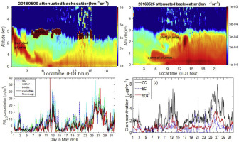
Abstract The wildfires in Fort McMurray of Alberta, Canada, injected large amounts of smoke aerosols in May 2016 and were identified as being one of Canada's major weather events of the year. This paper presents a synergistic remote sensing and in-situ measurement of the resultant smoke plume transport, optical properties, and its impacts on local air quality in New York City (NYC). Comparisons with the operational air quality model forecast (the NOAA National Air Quality Forecasting Capability, NAQFC) performance are presented. The aloft plume intrusions on May 9–13 and 25–29, 2016, and their mixing down into the planetary-boundary layer (PBL) were observed by a combined lidar, ceilometer and other measurement. A decrease in single-scattering albedo and absorption Angstrom exponent near one indicates that the plumes were absorbing aerosol dominated. Dramatic impacts of smoke transport on the ground air quality are demonstrated with a coincident increase of ground PM2.5 (from 5- to 25–30 μg/m3) in NYC urban and upwind rural area, enhancement of the PM2.5 speciation (organic carbon, elemental carbon, potassium ion (K+)) and the ozone exceedance of NAAQS. Using the satellite and model product, we show regional spatial distribution of smoke, multiple transport paths and wildfire sources. Finally, with the lidar vertical profiling observations, we evaluate the model PBL-height (PBLH) and PM2.5 during May 24th to 30th, 2016. The model PBLH shows consistent diurnal variation with the observed mixing layer height (MLH), but is clearly overestimated during the convective daytime hours. On the other hand, when estimating the MLH directly from the model PM2.5 profile, better agreement with observation was indicated. This helps explain the good agreement between the model PM2.5 and surface measurements except for the model overestimate during the morning of May 25 and 26, 2016.
中文翻译:

纽约市地面和卫星遥感观测到的大陆内野火烟雾传输及其对当地空气质量的影响
摘要 2016 年 5 月,加拿大艾伯塔省麦克默里堡的野火注入了大量烟雾气溶胶,被确定为加拿大今年的主要天气事件之一。本文介绍了对由此产生的烟羽传输、光学特性及其对纽约市 (NYC) 当地空气质量的影响的协同遥感和原位测量。展示了与运行空气质量模型预测(NOAA 国家空气质量预测能力,NAQFC)性能的比较。2016 年 5 月 9 日至 13 日和 25 日至 29 日的高空羽流侵入,以及它们向下混合到行星边界层 (PBL) 中,是通过激光雷达、云高仪和其他测量的组合观测到的。单散射反照率和吸收埃指数接近 1 的减少表明羽流以吸收气溶胶为主。纽约市城市和上风农村地区地面 PM2.5(从 5- 到 25-30 μg/m3)同时增加,PM2.5 形态(有机碳、元素碳、钾离子 (K+))和 NAAQS 的臭氧超标。使用卫星和模型产品,我们展示了烟雾、多条运输路径和野火源的区域空间分布。最后,通过激光雷达垂直剖面观测,我们评估了 2016 年 5 月 24 日至 30 日期间模型 PBL 高度(PBLH)和 PM2.5。模型 PBLH 显示出与观测到的混合层高度(MLH)一致的日变化,但在对流白天时间显然被高估了。另一方面,当直接从模型 PM2.5 分布估计 MLH 时,表明与观察结果的一致性更好。这有助于解释模型 PM2.5 与地表测量值之间的良好一致性,除了模型在 2016 年 5 月 25 日至 26 日上午的高估。
更新日期:2018-08-01
中文翻译:
纽约市地面和卫星遥感观测到的大陆内野火烟雾传输及其对当地空气质量的影响
摘要 2016 年 5 月,加拿大艾伯塔省麦克默里堡的野火注入了大量烟雾气溶胶,被确定为加拿大今年的主要天气事件之一。本文介绍了对由此产生的烟羽传输、光学特性及其对纽约市 (NYC) 当地空气质量的影响的协同遥感和原位测量。展示了与运行空气质量模型预测(NOAA 国家空气质量预测能力,NAQFC)性能的比较。2016 年 5 月 9 日至 13 日和 25 日至 29 日的高空羽流侵入,以及它们向下混合到行星边界层 (PBL) 中,是通过激光雷达、云高仪和其他测量的组合观测到的。单散射反照率和吸收埃指数接近 1 的减少表明羽流以吸收气溶胶为主。纽约市城市和上风农村地区地面 PM2.5(从 5- 到 25-30 μg/m3)同时增加,PM2.5 形态(有机碳、元素碳、钾离子 (K+))和 NAAQS 的臭氧超标。使用卫星和模型产品,我们展示了烟雾、多条运输路径和野火源的区域空间分布。最后,通过激光雷达垂直剖面观测,我们评估了 2016 年 5 月 24 日至 30 日期间模型 PBL 高度(PBLH)和 PM2.5。模型 PBLH 显示出与观测到的混合层高度(MLH)一致的日变化,但在对流白天时间显然被高估了。另一方面,当直接从模型 PM2.5 分布估计 MLH 时,表明与观察结果的一致性更好。这有助于解释模型 PM2.5 与地表测量值之间的良好一致性,除了模型在 2016 年 5 月 25 日至 26 日上午的高估。


 京公网安备 11010802027423号