Science of the Total Environment ( IF 9.8 ) Pub Date : 2018-01-12 , DOI: 10.1016/j.scitotenv.2018.01.086 Jie Liang , Xinyue He , Guangming Zeng , Minzhou Zhong , Xiang Gao , Xin Li , Xiaodong Li , Haipeng Wu , Chunting Feng , Wenle Xing , Yilong Fang , Dan Mo
|
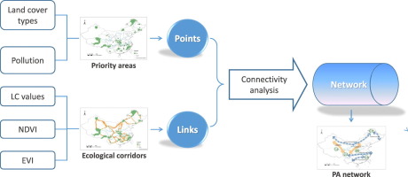
Considering that urban expansion and increase of human activities represent important threats to biodiversity and ecological processes in short and long term, developing protected area (PA) network with high connectivity is considered as a valuable conservation strategy. However, conservation planning associated with the large-scale network in China involves important information loopholes about the land cover and landscape connectivity. In this paper, we made an integrative analysis for the identification of conservation priority areas and least-cost ecological corridors (ECs) in order to promote a more representative, connected and efficient ecological PA network for this country. First, we used Zonation, a spatial prioritization software, to achieve a hierarchical mask and selected the top priority conservation areas. Second, we identified optimal linkages between two patches as corridors based on least-cost path algorithm. Finally, we proposed a new framework of China's PA network composed of conservation priority and ECs in consideration of high connectivity between areas. We observed that priority areas identified here cover 12.9% of the region, distributed mainly in mountainous and plateau areas, and only reflect a spatial mismatch of 19% with the current China's nature reserves locations. From the perspective of conservation, our result provide the need to consider new PA categories, specially located in the south (e.g., the middle-lower Yangtze River area, Nanling and Min-Zhe-Gan Mountains) and north regions (e.g., Changbai Mountains), in order to construct an optimal and connected national network in China. This information allows us better opportunities to identify the relative high-quality patches and draft the best conservation plan for the China's biodiversity in the long-term run.


 京公网安备 11010802027423号