当前位置:
X-MOL 学术
›
Environ. Pollut.
›
论文详情
Our official English website, www.x-mol.net, welcomes your feedback! (Note: you will need to create a separate account there.)
Integrated GIS and multivariate statistical analysis for regional scale assessment of heavy metal soil contamination: A critical review ☆
Environmental Pollution ( IF 8.9 ) Pub Date : 2017-09-19 , DOI: 10.1016/j.envpol.2017.07.021 Deyi Hou , David O'Connor , Paul Nathanail , Li Tian , Yan Ma
Environmental Pollution ( IF 8.9 ) Pub Date : 2017-09-19 , DOI: 10.1016/j.envpol.2017.07.021 Deyi Hou , David O'Connor , Paul Nathanail , Li Tian , Yan Ma
|
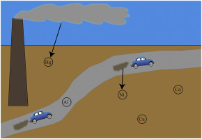
Heavy metal soil contamination is associated with potential toxicity to humans or ecotoxicity. Scholars have increasingly used a combination of geographical information science (GIS) with geostatistical and multivariate statistical analysis techniques to examine the spatial distribution of heavy metals in soils at a regional scale. A review of such studies showed that most soil sampling programs were based on grid patterns and composite sampling methodologies. Many programs intended to characterize various soil types and land use types. The most often used sampling depth intervals were 0–0.10 m, or 0–0.20 m, below surface; and the sampling densities used ranged from 0.0004 to 6.1 samples per km2, with a median of 0.4 samples per km2. The most widely used spatial interpolators were inverse distance weighted interpolation and ordinary kriging; and the most often used multivariate statistical analysis techniques were principal component analysis and cluster analysis. The review also identified several determining and correlating factors in heavy metal distribution in soils, including soil type, soil pH, soil organic matter, land use type, Fe, Al, and heavy metal concentrations. The major natural and anthropogenic sources of heavy metals were found to derive from lithogenic origin, roadway and transportation, atmospheric deposition, wastewater and runoff from industrial and mining facilities, fertilizer application, livestock manure, and sewage sludge. This review argues that the full potential of integrated GIS and multivariate statistical analysis for assessing heavy metal distribution in soils on a regional scale has not yet been fully realized. It is proposed that future research be conducted to map multivariate results in GIS to pinpoint specific anthropogenic sources, to analyze temporal trends in addition to spatial patterns, to optimize modeling parameters, and to expand the use of different multivariate analysis tools beyond principal component analysis (PCA) and cluster analysis (CA).
中文翻译:

集成的GIS和多变量统计分析用于重金属土壤污染的区域规模评估:关键审查☆
重金属土壤污染与对人类的潜在毒性或生态毒性有关。学者们越来越多地使用地理信息科学(GIS)与地统计和多元统计分析技术的组合来检查区域范围内土壤中重金属的空间分布。对此类研究的回顾表明,大多数土壤采样程序都基于网格模式和复合采样方法。许多程序旨在表征各种土壤类型和土地利用类型。最常用的采样深度间隔为地表以下0–0.10 m或0–0.20 m。所使用的采样密度为每km 2 0.0004到6.1个样本,中位数为每km 2 0.4个样本。使用最广泛的空间插值器是距离反比加权插值法和普通克里金法。最常用的多元统计分析技术是主成分分析和聚类分析。审查还确定了土壤中重金属分布的几个决定性因素和相关因素,包括土壤类型,土壤pH,土壤有机质,土地利用类型,铁,铝和重金属浓度。人们发现,重金属的主要自然和人为来源来自成岩成因,道路和运输,大气沉积,工业和采矿设施的废水和径流,肥料施用,牲畜粪便和污水污泥。这篇评论认为,集成GIS和多变量统计分析在评估区域规模土壤中重金属分布方面的全部潜力尚未完全实现。建议未来进行研究以在GIS中映射多变量结果,以查明特定的人为来源,分析空间格局以外的时间趋势,优化建模参数,以及将多变量分析工具的使用范围扩展到主成分分析之外( PCA)和聚类分析(CA)。
更新日期:2017-09-20
中文翻译:
集成的GIS和多变量统计分析用于重金属土壤污染的区域规模评估:关键审查☆
重金属土壤污染与对人类的潜在毒性或生态毒性有关。学者们越来越多地使用地理信息科学(GIS)与地统计和多元统计分析技术的组合来检查区域范围内土壤中重金属的空间分布。对此类研究的回顾表明,大多数土壤采样程序都基于网格模式和复合采样方法。许多程序旨在表征各种土壤类型和土地利用类型。最常用的采样深度间隔为地表以下0–0.10 m或0–0.20 m。所使用的采样密度为每km 2 0.0004到6.1个样本,中位数为每km 2 0.4个样本。使用最广泛的空间插值器是距离反比加权插值法和普通克里金法。最常用的多元统计分析技术是主成分分析和聚类分析。审查还确定了土壤中重金属分布的几个决定性因素和相关因素,包括土壤类型,土壤pH,土壤有机质,土地利用类型,铁,铝和重金属浓度。人们发现,重金属的主要自然和人为来源来自成岩成因,道路和运输,大气沉积,工业和采矿设施的废水和径流,肥料施用,牲畜粪便和污水污泥。这篇评论认为,集成GIS和多变量统计分析在评估区域规模土壤中重金属分布方面的全部潜力尚未完全实现。建议未来进行研究以在GIS中映射多变量结果,以查明特定的人为来源,分析空间格局以外的时间趋势,优化建模参数,以及将多变量分析工具的使用范围扩展到主成分分析之外( PCA)和聚类分析(CA)。


 京公网安备 11010802027423号